Pseudo-satellites, a world of solutions and applications

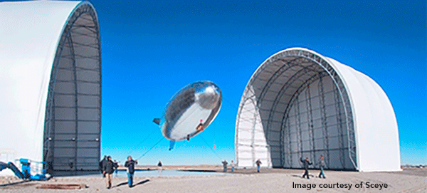
High Altitude Pseudo Satellites (HAPS) are aerial platforms that operate in the stratosphere, at an average altitude of 20 km, above commercial airlines, strong jet-stream currents and the humidity of the troposphere. Broadly speaking, HAPS follow two structural design types: gliders, which are heavier than air (HTA), and airships or balloons, lighter than the surrounding air (LTA). The use of HAPS in combination with satellite missions is promising for telecommunications and Earth observation applications.
The relative proximity of HAPS to the Earth has clear technical advantages; these platforms remain in flight for weeks or months, returning to the base for maintenance when needed. The stable location of LTA airships allows recording data in video mode, while the mobility of HTA gliders allows recording data of the same object from different angles. HAPS improve spatial resolution remarkably as a result of their closer positioning to observed objects; data transmission enjoys lower latency compared to satellites, increasing the efficiency of the ground segment units. In addition, contrary to the discrete data gathering capacity of ground stations, HAPS register data seamlessly, for example of the atmospheric column and the sea surface, and without topographic interference.
The European Space Agency has shown interest in the future of HAPS, issuing a study to determine HAPS complementarity to satellites for air quality applications. Therefore, HAPSVIEW was born in order to demonstrate the added value of HAPS to air quality models deriving from local measuring networks and satellite observations.
GMV is leading the HAPSVIEW project, in collaboration with the Royal Dutch Meteorological Institute (KNMI), the Swiss company SCEYE, developer of the LTA navigator, and the Canadian firm ABB, specializing in airborne and spaceborne remote sensing instruments. Four Public Institutions responsible for the control, monitoring, management and reporting of air quality are taking part in the study as key end users: the Greater Rotterdam Authority and the Rotterdam City Council, as well as the Andalusian Government and the Seville City Council.
Air quality in Rotterdam and Seville, as in other European cities, presents challenges for public health and for the fulfillment of the Paris Agreement, in the context of the United Nations Framework Convention on Climate Change that establishes measures for the reduction of greenhouse gas emissions.
In the course of the study, the consortium will identify user requirements regarding air quality in Rotterdam and Seville, suitable HAPS platforms, the payload, the ground segment and the HAPS mission requirements. An analysis will also be made of airspace regulation, the products associated with the observed data and the synergies with satellite missions. Any HAPS limitations or shortfalls will be studied for further system evolution discussions.
There is nowadays an increasing awareness of the importance of environmental protection not only to guarantee future generations’ natural legacy for but also to ensure clean air in our urban environments, especially if we take into account that 54% of the world's population lives in urban areas, according to the United Nations urban population analysis of 2018.
HAPSVIEW was presented in September to the scientific community gathered at the ESA Phi-Week contest, an event that explores cutting-edge technologies for the benefit of future satellite missions and Earth observation services.