Eomarine
Earth Observation services for Marine and Maritime Monitoring
Eomarine - Earth Observation services for marine and maritime monitoring
Eomarine is the GMV’s catalogue of marine- and maritime-related geo-information products, derived from satellite Earth Observation data.
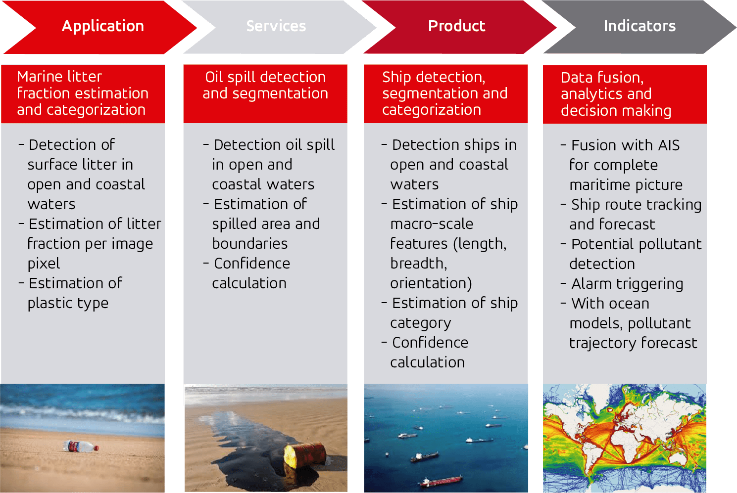
Eomarine services includes marine-litter detection, fraction estimation and categorization; oil-spill detection and segmentation; and ship detection, segmentation and categorization.
Eomarine is aligned with the Maritime Space Planning (MSP) and supports the implementation of the Paris Agreement, the Sendai Framework for Disaster Risk Reduction, the SDG 14 for sustainable use of oceans, and the pledges from UNFCCC climate summits.
For any question or request, please contact us at [email protected]
in providing Earth Observation marine and maritime services.
in all the world use our marine and maritime services.
Highlights

Key applications:
- Marine and maritime near-real time monitoring.
- Marine and maritime scenario fore- and back-ward analysis.
- Marine and maritime risk assessment and policy verification.

10 Earth Observation products for strengthening a sustainable exploitation of marine and maritime resources to support the endeavour to keep Earth being the blue planet.

Eomarine meets all existing geospatial data standards. Products can be consumed by any GIS through OGC standard services.
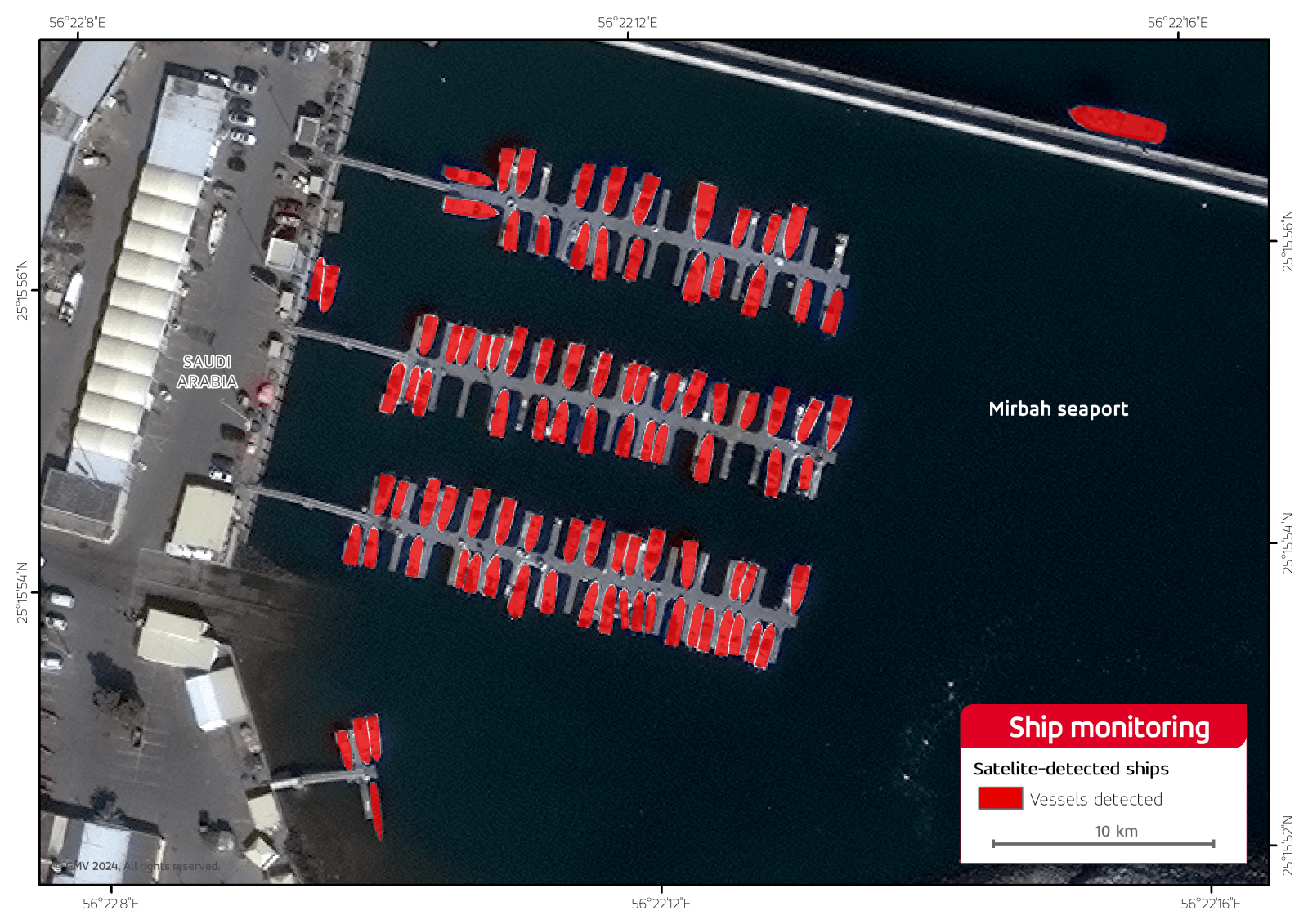
Ship Detection, Segmentation and Categorization
The product is dedicated to the detection and segmentation of ship signatures in remote sensing images, both at the radar and optic regime. Trained Artificial Intelligence models are used to automatically detect and isolate the area that ships cover in remote sensing images. In complement, confidence values and a set of macro-scale features are estimated.
- Automatic processing with no operator intervention and responsiveness time aligned with near-real time operations (<30s per 1 GB of data)
- High accuracy on segmenting ship area over sea surface with high robustness against undesired effects, like reflectivity peaks or sun glint
- Computation of length, breadth, 180º direction, and confidence value
- Competitive false alarm ratio (<5%), probability of detection (>90%) and Intersection over Union (>75%). Values are nominal and can slightly depend on the ocean region. All overperform current state of the art.
- Eight macro-scale categories are defined: oil tanker, bulk, container, coaster, tug, ro-ro, ferry, non-metallic ship
- Competitive commission error (<30%) with no extra ancillary data support. Values are nominal and can slightly depend on the ocean region. All overperform current state of the art.
Consolidation of ship tracks
The product is dedicated to the consolidation of ship tracks by fusing diversified data sources, including AIS, EO-extracted ship detection and categorization reports, LRIT, VMS and others. Fusion is driven by certain rules to keep consistency on the track.
- Automatic processing with no operator intervention and responsiveness time aligned with near-real time operations.
- Automatic compensation of image induced aberrations and shifts in order to come with clean ship tracks.
- Post-processing rules to avoid the misassignment of the positions of a particular ship towards an incorrect nearby route.
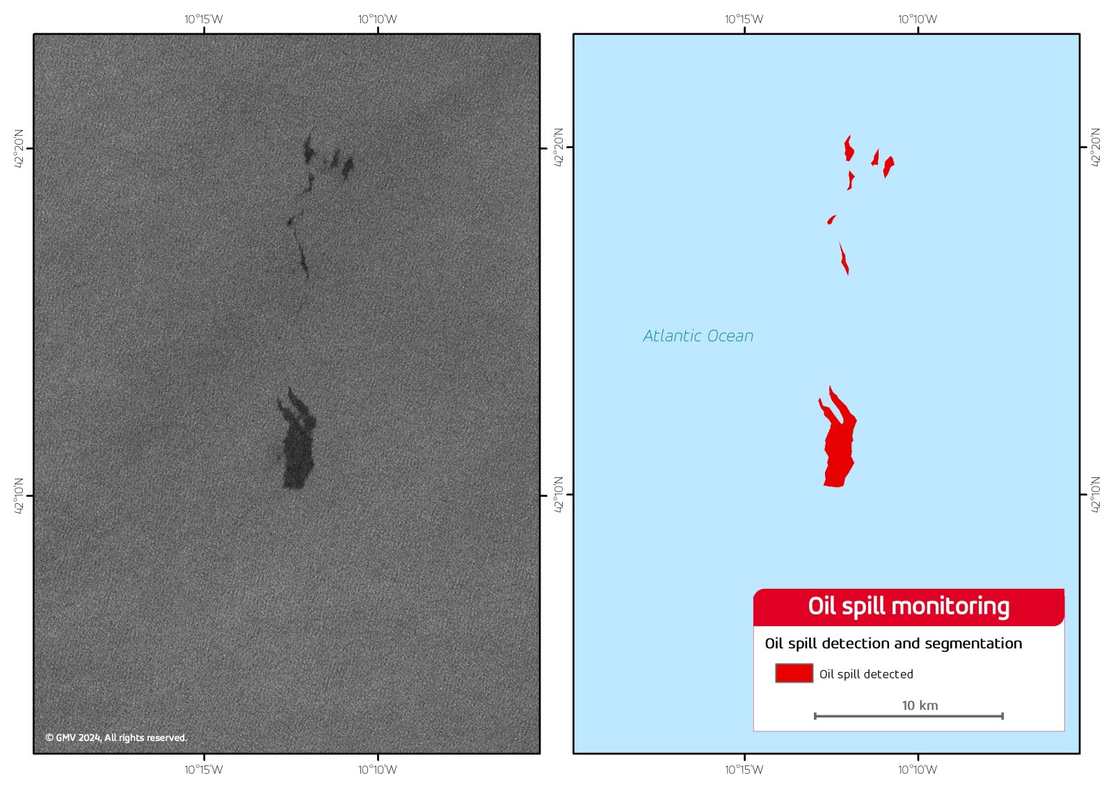
Oil spill detection and segmentation
The product is dedicated to the detection and segmentation of oil signatures in remote sensing images, both at the radar and optic regime. Trained Artificial Intelligence models are used to automatically detect and isolate the area that oil cover in remote sensing images. In complement, confidence values and a set of macro-scale features are estimated.
- Automatic processing with no operator intervention and responsiveness time aligned with near-real time operations (<30s per 1 GB of data).
- High accuracy on segmenting oil area over sea surface with high robustness against undesired effects, like low sea surface wind conditions or irregular internal waves.
- Computation of spilled area.
- Competitive false alarm ratio (<5%), probability of detection (>90%) and Intersection over Union (>75%). Values are nominal and can slightly depend on the ocean region. All overperform current state of the art.
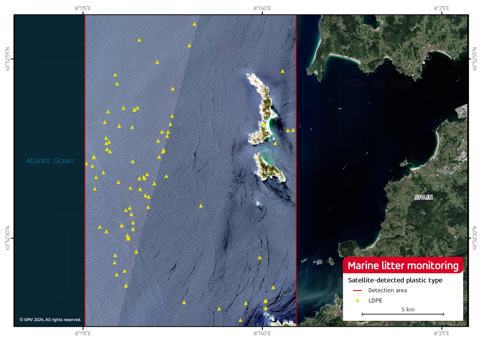
Marine litter fraction estimation and categorization
The product is dedicated to the detection marine litter fraction within each pixel of remote sensing images, only in the optic regime. Trained Artificial Intelligence models are used to automatically predict marine litter fraction pixelwise in optic remote sensing images.
- Automatic processing with no operator intervention and responsiveness time aligned with near-real time operations (<30s per 1 GB of data).
- Capability to work in the fraction range between 5% and 30%. Work is being underperformed to extend this range.
- High accuracy on marine litter fraction prediction with omission and commission errors < 30 %. All overperform current state of the art.
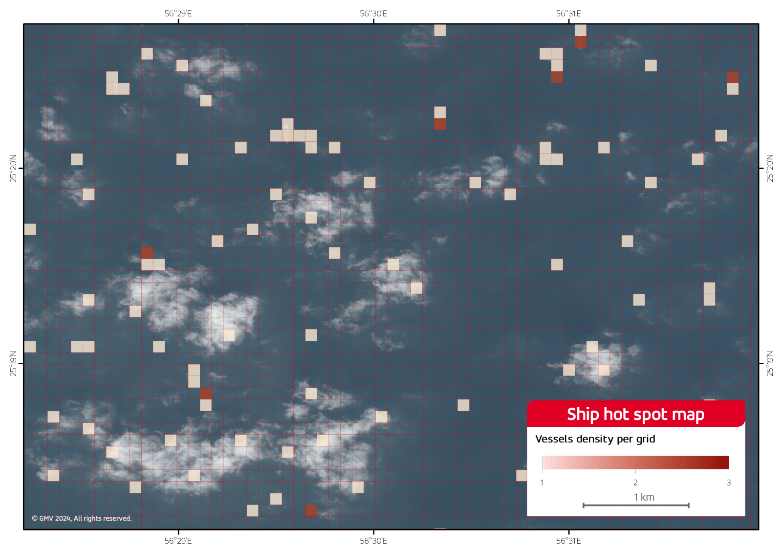
Ship route estimation
The product is dedicated to the estimation of ship route at short-term into the future or back into the past by taking the current and historical route picture into account as well as ocean sea conditions and other factors, like transportation corridors.
- Automatic processing with no operator intervention and responsiveness time aligned with near-real time operations.
- Automatic compensation of aberrations and shifts in order to come with clean ship tracks.
- Post-processing rules to avoid the misassignment of the positions of a particular ship towards an incorrect nearby route.
- Generation of hot spot maps with the accumulation of the different positions that have been estimated for the set of objects of interest. Such maps can be generated for a single track and/or a specific subset of tracks in accordance to a set of rules.
Oil route estimation
The product is dedicated to the estimation of oil route at short-term into the future and back into the past by taking the current and historical route picture into account as well as ocean sea conditions and other factors, like bathymetry and/or coastal orography.
- Automatic processing with no operator intervention and responsiveness time aligned with near-real time operations.
- Automatic compensation of aberrations and shifts in order to come with clean oil routes.
- Generation of hot spot maps with the accumulation of the different positions that have been estimated for the set of objects of interest. Such maps can be generated for a single track and/or a specific subset of tracks in accordance to a set of rules.
Litter route estimation
The product is dedicated to the estimation of litter route at short-term into the future and back into the past by taking the current and historical route picture into account as well as ocean sea conditions and other factors, like bathymetry and/or coastal orography.
- Automatic processing with no operator intervention and responsiveness time aligned with near-real time operations.
- Automatic compensation of aberrations and shifts in order to come with clean litter routes.
- Generation of hot spot maps with the accumulation of the different positions that have been estimated for the set of objects of interest. Such maps can be generated for a single track and/or a specific subset of tracks in accordance to a set of rules.
Ship alarm monitoring
The product is dedicated to the triggering of alarms for the routes consolidated by the ship tracking, and ship route estimation services in accordance to a set of predefined alarms.
- Automatic processing with no operator intervention and responsiveness time aligned with near-real time operations.
- Definition of risk assessment reports by aggregating the alarms that have been raised in a specific period of time. Such reports can permit characterizing certain patterns of behaviour.
- Flexibility on defining alarms in terms of ancillary data.
- Flexibility on alarm notification.
Oil alarm monitoring
The product is dedicated to the triggering of alarms for routes consolidated by the oil route fore-estimation service in accordance to a set of predefined alarms.
- Automatic processing with no operator intervention and responsiveness time aligned with near-real time operations.
- Definition of risk assessment reports by aggregating the alarms that have been raised in a specific period of time.
- Flexibility on defining alarms in terms of ancillary data.
- Flexibility on alarm notification.
Litter alarm monitoring
The product is dedicated to the triggering of alarms for routes consolidated by the litter route fore-estimation service in accordance to a set of predefined alarms.
- Automatic processing with no operator intervention and responsiveness time aligned with near-real time operations.
- Definition of risk assessment reports by aggregating the alarms that have been raised in a specific period of time.
- Flexibility on defining alarms in terms of ancillary data.
- Flexibility on alarm notification.