With LUPIN, GMV marks a new era in automated lunar exploration
The multinational technology company GMV has just presented the latest results for the project known as LUPIN (Enabling High-Performance PNT in the Lunar Environment), after carrying out field testing from April 27th to May 8th in the municipality of La Oliva, on the Spanish island of Fuerteventura. This is an innovative initiative of the European Space Agency (ESA), which has the aim of developing a prototype navigation system to simulate the signals that lunar surface rovers are expected to receive in the future. The result will be a navigation system similar to GPS, but for use on the surface of the Moon. This will provide a navigation tool similar to Google Maps for users such as rovers and astronauts.
In a context of renewed interest in lunar exploration, the development of advanced technologies to support rovers, landers, and even the presence of humans on the surface of the Moon has become a strategic priority for the space industry. In view of this, the ESA is now carrying out this groundbreaking project as part of its Navigation Innovation and Support Program (NAVISP). The aim is to test new positioning, navigation, and timing (PNT) technologies that will be able to support exploration of the lunar surface and other applications. These technologies will combine current approaches to planetary PNT with distance measurement signals from the future Lunar Communication Navigation System (LCNS). These are satellite signals that will be used in the same way as GPS signals are used on Earth, although in this case the satellites will be in orbit around the Moon. This system will also be adapted to particular areas of interest (for example, the lunar south pole, the far side of the moon, and permanently shadowed regions).
Existing lunar navigation capabilities are subject to some significant limitations. Unlike the Earth, the Moon does not have a positioning satellite infrastructure like the Global Positioning System (GPS). This means that spacecraft and rovers are unable to determine their precise location in real time. Instead, they have to rely upon internal calculations and data sent from Earth. To overcome these restrictions, GMV has developed the LUPIN lunar navigation prototype for the ESA. Over the course of the next decade, this technology will revolutionize the way in which astronauts and vehicles operate on the surface of the Moon. LUPIN will reduce the current dependency on onboard systems that use complex algorithms to determine relative locations, and this will optimize the performance and efficiency of lunar surface exploration vehicles.
This advancement will not only improve precision, it will also allow determination of faster and more efficient routes, while reducing the computational load that must now be dedicated to navigation. As a result, only the conditions of the lunar surface will limit the speeds that rovers can travel, rather than technical limitations, and this will mark the beginning of a new era in automated lunar exploration.
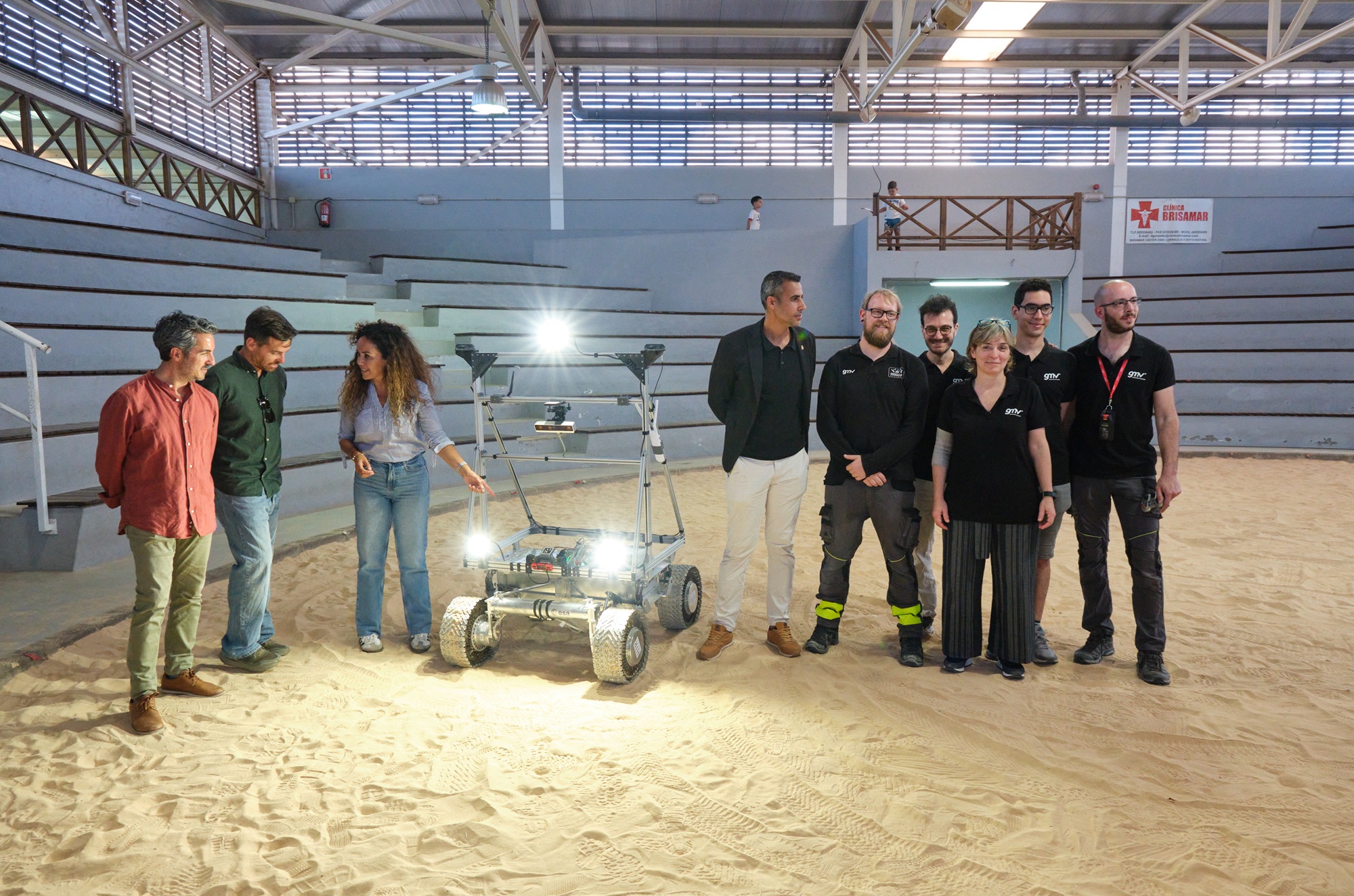
During the testing campaign carried out on the Spanish island of Fuerteventura, the real-time navigation system was successfully verified and validated. This was done via a series of tests that simulated the conditions of the LCNS positioning and precise location signals that will be received in the future by lunar surface rovers.
Once the tests had been successfully completed, a presentation ceremony was held at the wrestling arena in the town of Lajares. At this event, the municipal mayor of La Oliva, Isaí Blanco, emphasized that it was “an honor for the Municipal Council of La Oliva to host this project, which represents such an innovative initiative. The success of this field testing demonstrates that our island, and specifically the La Oliva area, can accommodate tests of this nature, which represent a remarkable scientific advancement, without causing damage to the environment.”
Fuerteventura’s Minister of Innovation, Rayco Leon, explained that the island has proven to be an excellent testing ground for aerospace technologies, as evidenced by significant projects such as those taking place at the Fuerteventura Technology Park. These are helping to diversify the local economy in specialized areas, and he pointed out that it is important to continue to carry out innovative projects like these, so that Fuerteventura can be the site of groundbreaking initiatives such as the one presented at the event.
Mariella Graziano, GMV’s Manager of Strategy and Business Development for Science, Exploration and Transportation Strategy, and Steven Kay, GMV’s manager for the LUPIN project, were responsible for explaining the field tests performed and the corresponding details. According to Steven Kay, “we were able to successfully compile data over the course of 7 kilometers of travel, and at various speeds, from the conventional 0.2 meters per second, up to much faster speeds of 1.0 meters per second, which are the speeds of the future. In addition, we were able to simulate a whole range of lunar conditions and types of environments. This included tests performed at night, using a combination of simulated sunlight to emulate the illumination conditions found on the Moon, as well as tests performed in total darkness, using only the rover’s onboard lighting system to navigate. Mariella Graziano added some additional details: “the team has being working extremely hard here on Fuerteventura, conducting tests to support the development of a potential user segment PNT system that can provide precise positioning information for future lunar missions. At GMV we like to push the limits of technology, so we can make the future available today.”
Current lunar navigation technologies and their limitations, compared to terrestrial systems such as Google Maps
Lunar exploration has come a long way since the time of the first Moon landings in the 20th century. Missions such as NASA’s Artemis program, China’s Chang'e landings, and India’s Chandrayaan project are all using sophisticated technologies to navigate on the surface of the Moon. However, they are doing this in a way that is still far from offering the precision and fluidity that we experience on Earth with applications such as Google Maps.
Lunar missions are now using a combination of inertial navigation systems (INS), optical cameras, altitude sensors (LIDAR), and digital maps generated by satellites in orbit. Those maps make it possible to plan routes with relative precision, identify obstacles, and determine areas of scientific interest. They also allow lunar landings to take place with margins of error that continue to decrease.
In addition, some modules are experimenting with limited autonomous navigation, by using computer vision algorithms to perform real-time comparisons with previously stored maps. This technology is especially useful when communications with Earth are subject to delays, or when exploring regions on the far side of the Moon.
However, although lunar mapping has improved significantly, it remains incomplete and static. There is no real‑time updating, or information about how the terrain may have been changed by recent impacts or movements of lunar dust. Existing communications also depend upon direct visibility with the Earth, or on the use of relay satellites in lunar orbit. These factors generate communication shadow zones and lag times, and this makes it harder to make immediate decisions.
In contrast, systems like Google Maps benefit from a global network of GPS satellites, continuous mobile connectivity, sensors in millions of devices, and dynamic updating. This makes it possible for us to know our exact position instantly, receive directions with one‑meter accuracy, and access information about our surroundings such as traffic information, nearby services, and land use changes. Features like these require a planetary infrastructure that simply doesn’t exist on the Moon.
More info:
Corporate Marketing and Communications
[email protected]