Eoclima
Earth Observation Services for Climate Resilience

Eoclima – Earth Observation Services for Climate Action
Eoclima is GMV’s catalogue of climate-related geo-information products, derived from satellite Earth Observation data
Eoclima climate services include climate change risk assessment and monitoring, support for climate change adaptation solutions, and contributions to climate adaptation-mitigation synergistic approaches for land use and forestry regulation.
Eoclima is aligned with REDD+ and supports the Paris Agreement, the Sendai Framework for Disaster Risk Reduction, SDG 13 for climate action, and the pledges from UNFCCC climate summits.
For questions or requests, please contact us at [email protected]
in providing Earth Observation climate services
in all the world use our climate services
Highlights
Key applications:
- Climate risk management and adaptation
- Climate risk assessment and monitoring
- Climate adaptation and mitigation synergies

45 Earth Observation products for strengthening climate resilience to cope with the impacts of climate change

Eoclima meets all existing geospatial data standards. Products can be consumed by any GIS through OGC standard services.
This product is dedicated to the identification, delineation and impact assessment of riverine flood events, analysis of socio-economic /ecosystem impacts, current river flood risk estimates for different return periods and river flood risk using future projections and RCP scenarios.
- Hydrological & hydraulic modelling
- Flood risk management
- Analyses of historical flood events
- Estimations of water reservoir storage
- Water resources management
- Support financial disclosure reports
This product is dedicated to the identification of flood-prone areas using Earth Observation from regional to national scale. By analyzing satellite imagery from diverse sensors, this product pinpoints flood-prone regions, their maximum extent, and the frequency of flooding.
- Hydrological and hydraulic modelling
- Flood risk assessment and disaster management
- Analysis of historical flood events
- Water resources and reservoir storage monitoring
- Seasonal patterns and water dynamics analysis
- Support for financial disclosure and climate risk reporting
This product provides time-series information on the occurrence and frequency of water bodies and their extent, and anomalies in the total water storage. The surface water mapping includes water reservoirs, lakes, and rivers, while the total water storage comprises canopy water, water bodies, soil moisture and groundwater, and it represents a proxy for hydrological dynamics.
- Identifying water dynamics and anomalies
- Hydrological and drought modelling
- Agriculture, livestock, and water supply planning
- Food and nutrition security
- Energy and industrial water use
- Ecosystem and natural resource management
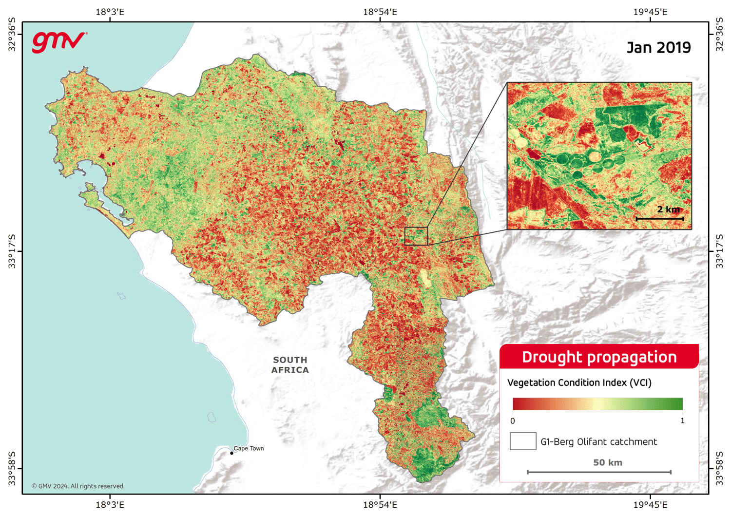
This product provides time-series information and includes analysis of precipitation, evapotranspiration patterns, soil moisture anomalies, decrease of water bodies’ extents, total water storage anomalies and climate drought indexes.
- Identifying meteorological droughts
- Identifying hydrological droughts
- Detecting and monitoring of long-term hydrological drought conditions
- Drought early warning decision support
- Drought modelling
- Mitigation of drought impacts
- Rainfed and irrigated agriculture
- Domestic water supply
- Aquatic and terrestrial ecosystems management
- Hydropower
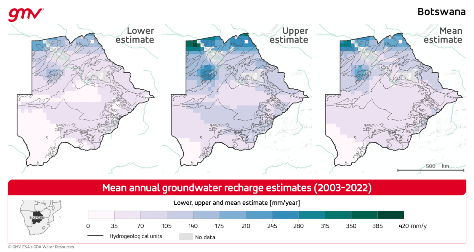
This product provides groundwater status through Groundwater Storage Anomalies. Based on the combination of Earth Observation data and land surface model outputs, it includes estimates of annual groundwater recharge, monitoring of groundwater drought conditions, and quantification of groundwater abstractions.
- Identifying water dynamics
- Water supply
- Water resources management
- Identifying hydrological droughts
- Detecting and monitoring long-term hydrological drought conditions
- Drought modelling
- Mitigation of drought impacts
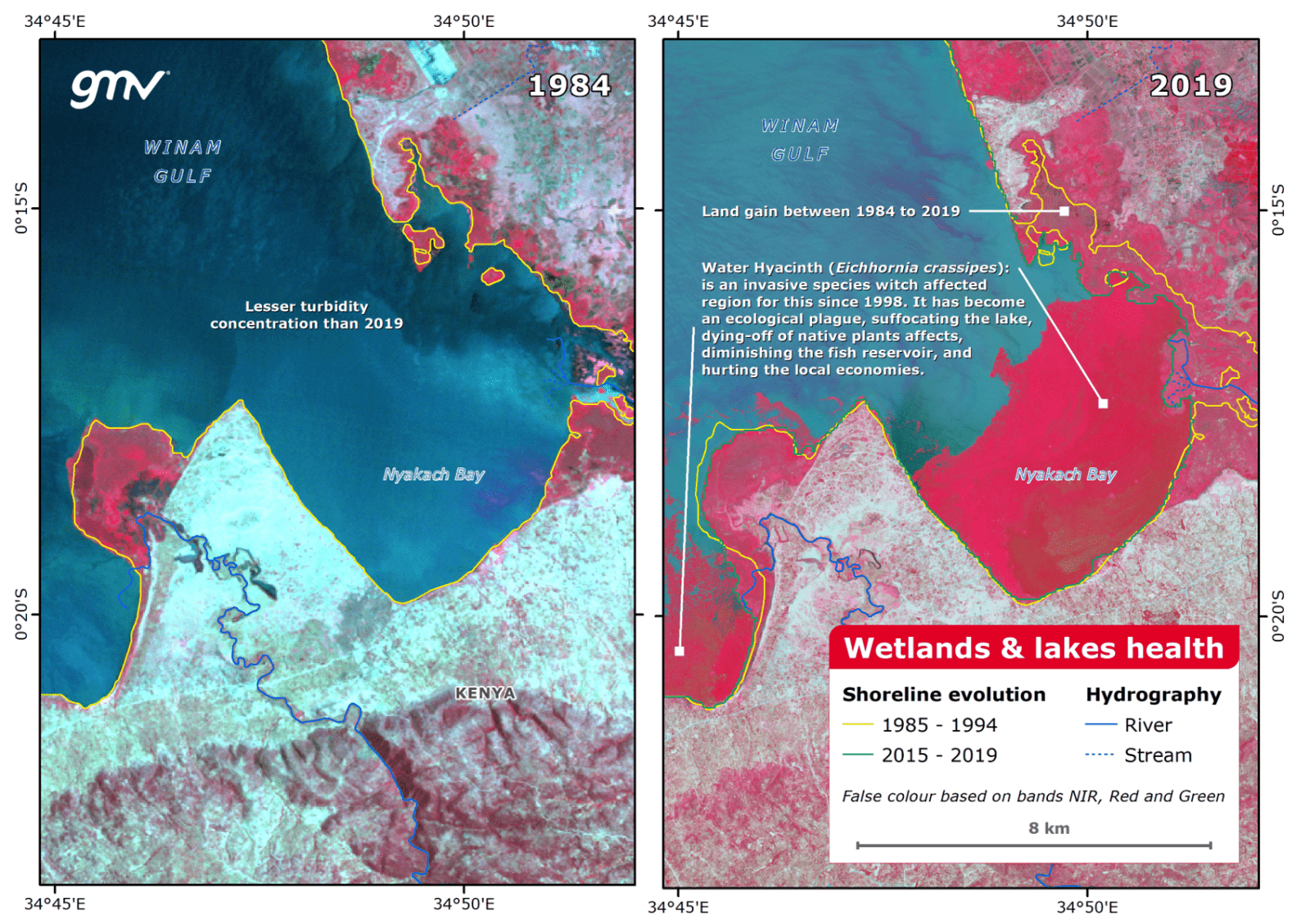
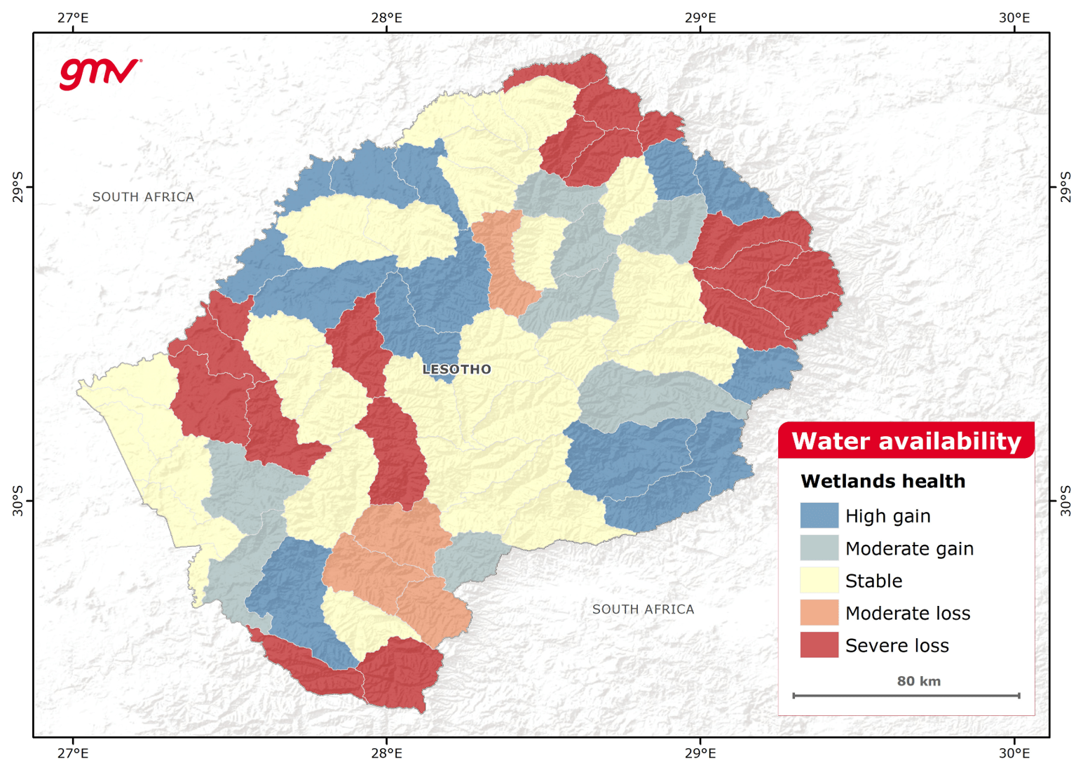
This product provides identification of wetlands and permanent water bodies, and monitoring of both seasonal and climate-driven long-term changes including water quality, level and extent. The product determines wetlands degradation trends and dynamics and reports advanced statistical analyses.
- Consolidation of wetlands inventory
- Identification of wetlands restoration opportunities
- Monitoring of environmental trends in wetlands
- Water supply management
- Ecosystem management
- Agriculture and livestock
- Advocacy and lobbying on wetlands
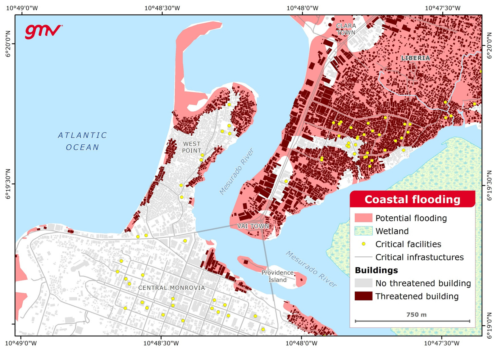
This product identifies, delineates, and grades flood events and maps flooding potential in coastal and riverine environments. Flooding likelihood integrates analyses of coastal erosion, sea level rise, and land subsidence using Earth Observation data.
- Urban planning
- Disaster risk management
- Coastal risk management
- Coastal adaptation and risk reduction strategies
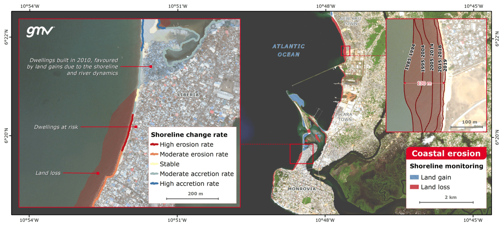
This product evidences the shoreline changes for a defined time period. Shoreline change monitoring utilizes a consistent and reliable water body detection based on combined satellite optical and SAR imagery. Accretion and erosion levels are derived from the shoreline changes and the geomorphologic analysis of the coast.
- Urban planning
- Vulnerability assessment
- Coastal risk management
- Coastal adaptation and risk reduction strategies
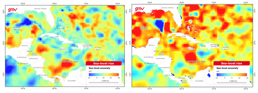
The product provides access to both historic and projected global time-series information on sea level changes and anomalies. Historic changes in sea level are observed using satellite SAR altimetry technology and future changes are estimated using climate projections from global and regional climate model ensembles for different GHG emission scenarios.
- Urban planning
- Vulnerability assessment
- Coastal risk management
- Coastal adaptation and risk reduction strategies
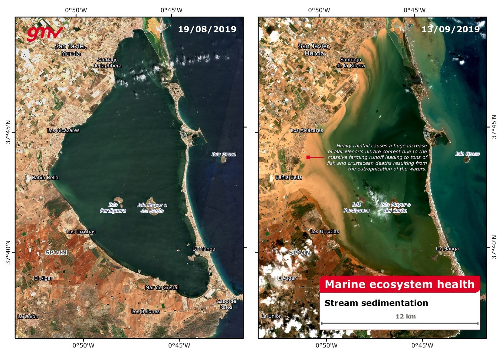
This product provides information on the factors that affect productivity, species diversity, and climate change resilience of marine ecosystems. Derived from Earth Observation data, this information contributes to marine ecosystem analyses by monitoring sea surface temperature, ocean color, and algae blooms.
- Marine ecosystem health studies
- Suitability analyses for fishery locations
- Ecosystem management
- Analyses of marine productivity and species diversity
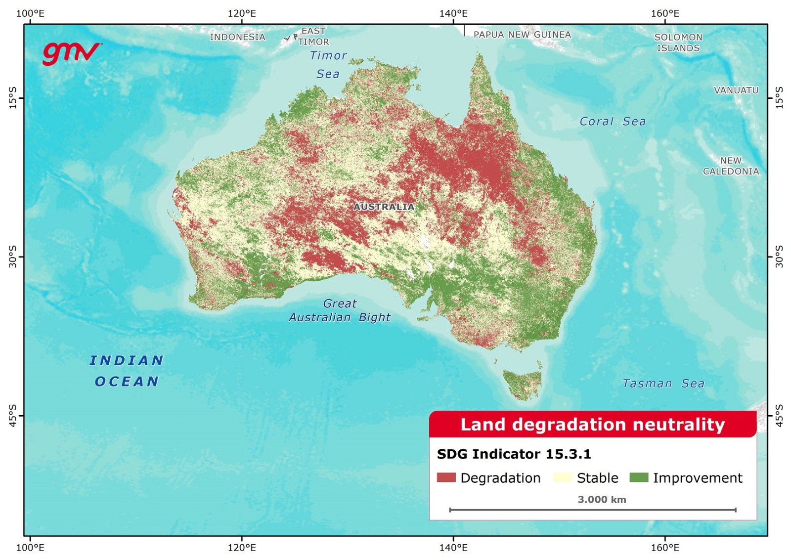
This product provides a classification of potential degraded/not-degraded areas based on time-series analyses of trends in land cover, plant productivity, and carbon stock (SOC and biomass) following Version 2 of the UNCCD’s Good Practice Guidance for calculating SDG Indicator 15.3.1.
- Investment planning
- Identifying rehabilitation opportunities
- Ecosystem management planning
- Monitoring Sustainable Development Goal Indicator 15.3.1
- Ecosystem-based adaptation and evaluation
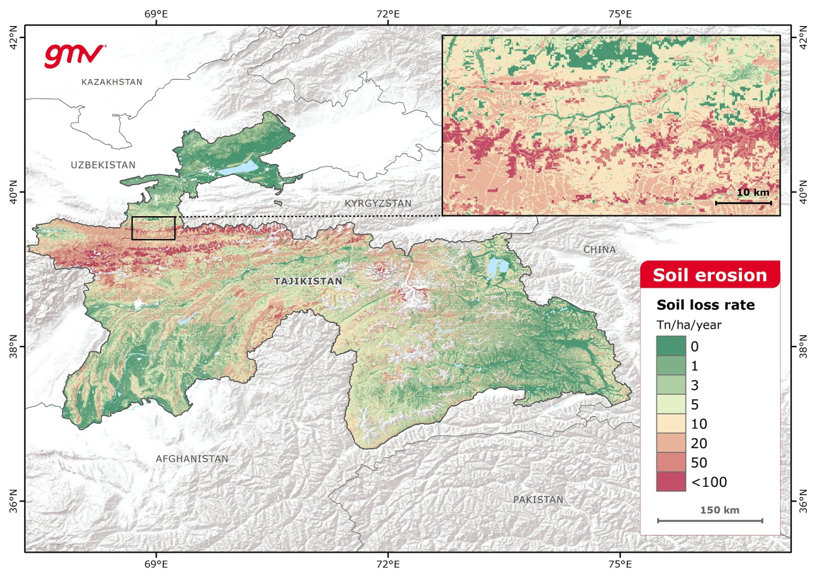
This product provides water-related soil erosion rates at annual intervals. Soil loss rates are measured in Tn/ha/year using the RUSLE2015 model and Earth Observation datasets. Factors affecting the soil loss calculation include rainfall erosivity, soil erodibility, topography, and cover-management.
- Land use management
- Support for intervention policies at country and regional level
- Identifying restoration opportunities
- Impact assessment of soil erosion mitigation measures
- Monitoring rehabilitation measures
- Climate policy formulation
- Tracking changes due to climate variability over time
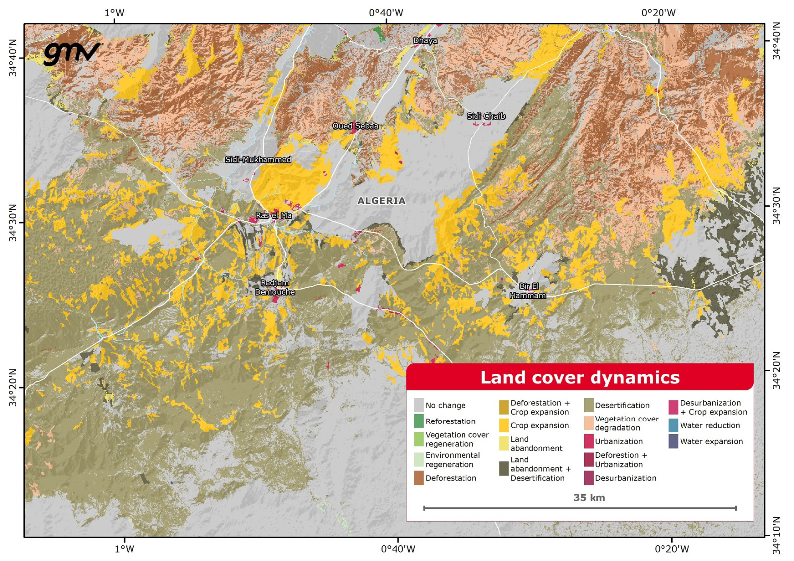
This product provides information about land cover and land use transitions of defined areas and for specified time intervals and can be aggregated for biomes or ecoregions upon request. The methodology to create the LULC map leverages the information from combined satellite optical and SAR time-series imagery. Transitions include deforestation, reforestation, crop expansion, urbanization, water expansion, water reduction, wetland degradation, and land abandonment.
- Land use management
- Monitoring environmental changes
- Land cover trends analyses
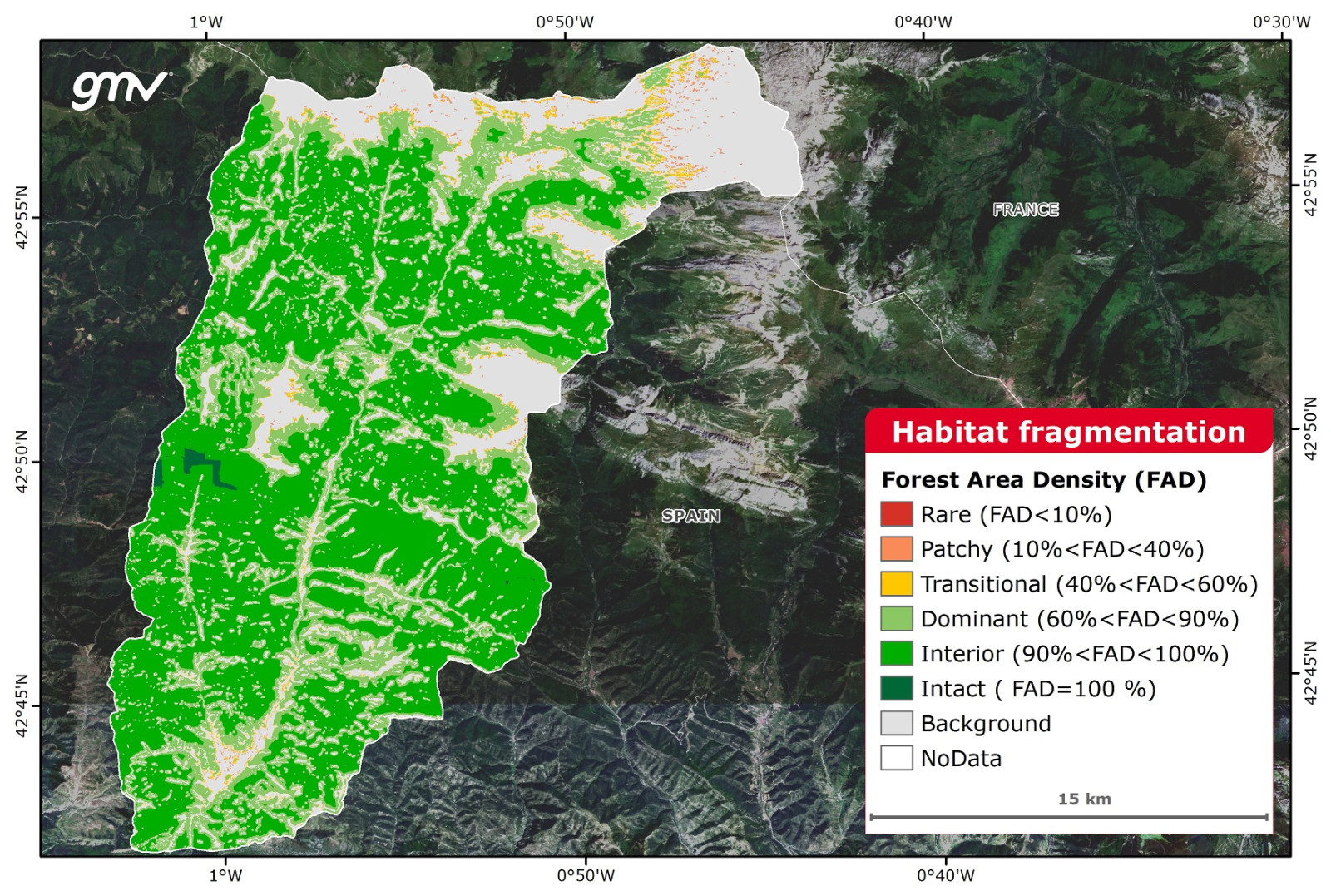
This product describes the emergence of discontinuities in an ecosystem. Fragmented habitats are identified by classifying spatial patterns using optical and SAR imagery, and measuring area density to quantify the fragmentation.
- Infrastructure and urban planning
- Forest management
- Ecosystem management
- Connectivity, diversity, and wildlife population studies
- Developing wildlife corridors
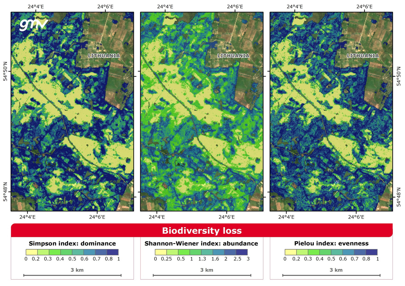
This product provides data on the decline or disappearance of biological diversity by analyzing an ecosystem’s intrinsic diversity. It calculates various diversity indexes that consider the number of species present, as well as the relative abundance, dominance, and evenness of each species.
- Ecosystem management
- Ecosystem economic assessment
- Forest management
- Food and nutrition security
- Harvesting wild medicinal plant species
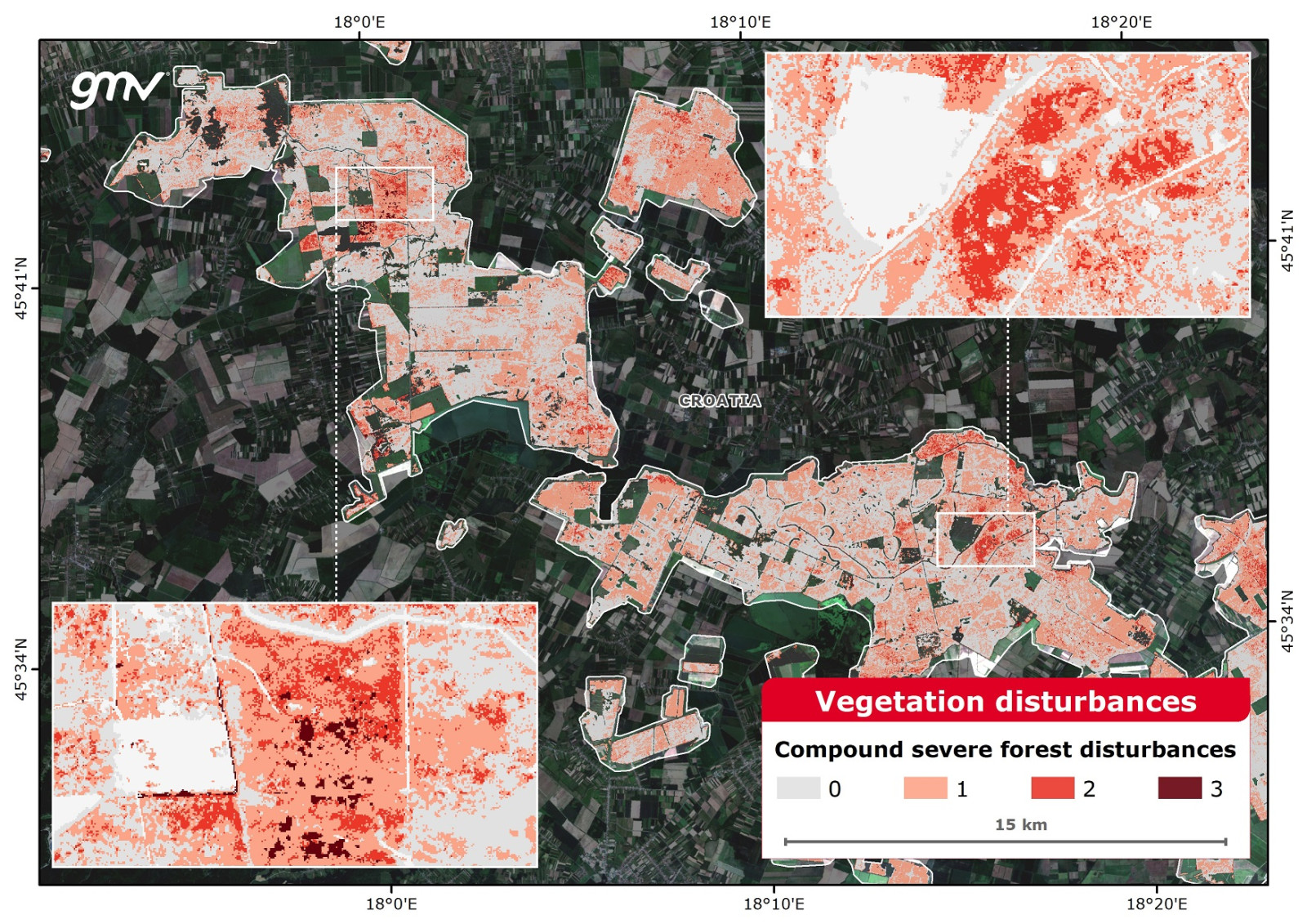
This product provides information about the most common disturbances that occur in nature and significantly affect vegetation dynamics. It makes calculations using EO-based products that hone in on biophysical vegetation indicators, combining information on deforestation, fires, vegetation stress, and biotic damage affecting the vegetation of the ecosystem.
- Ecosystem management
- Forest management
- Ecology studies
- Climate-driven disturbance analyses
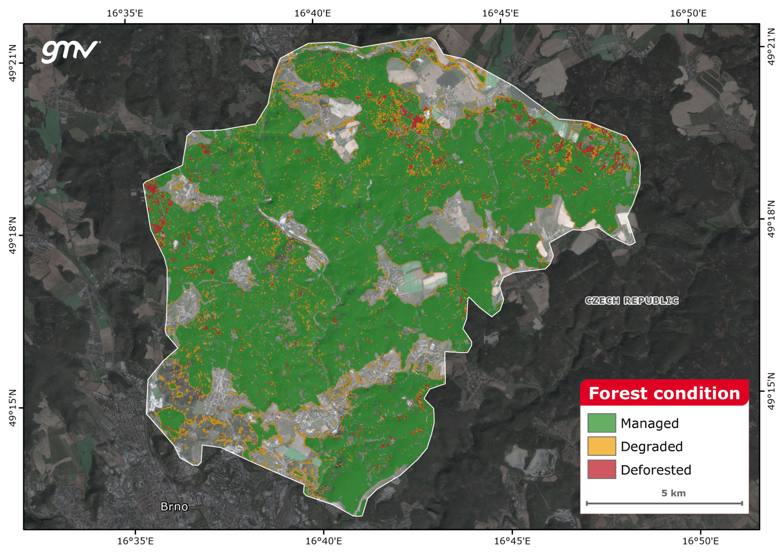
The product characterizes a forested area for a reference period and reports deterioration in the forest health status by assessing the damage caused by forests threats, including forest clearing, extreme drought and insect plagues. Robust statistical algorithms are applied over time-series of vegetation indices to correlate forest health decrease with the intensity of the climate-driven damage.
- Sustainable forest management and conservation practices
- Tracking forest logging
- Forest monitoring
- Plague-damage detection system
- Lobbying and advocacy
- Forestry project monitoring and evaluation
The product provides the mapping and long-term monitoring of forest covers using satellite-derived forest mask information. The analysis of the forest mask time-series reports the mapping of forest presence, absence and changes, and forest density. The product includes the detection of natural deforestation as well as detection of logged forest.
- Sustainable forest management and conservation practices
- Tracking forest logging
- Monitor deforestation in supply chains
- Forest monitoring
- Lobbying and advocacy
- Forestry project monitoring and evaluation
- Land use planning
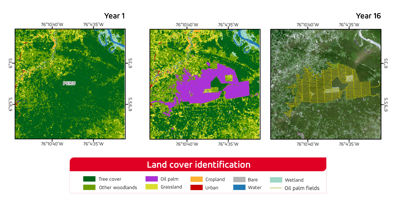
The product provides mapping and identification of agroforestry commodities and orchards, such as cocoa trees or oil palms; are crucial for an accurate assessment of dynamics and changes in native forests. Sustainable forest management and conservation practices.
- Forest monitoring
- Tracking forest logging
- Monitor deforestation in supply chains
- Land use management
- Land use planning
- Identification of restoration opportunities
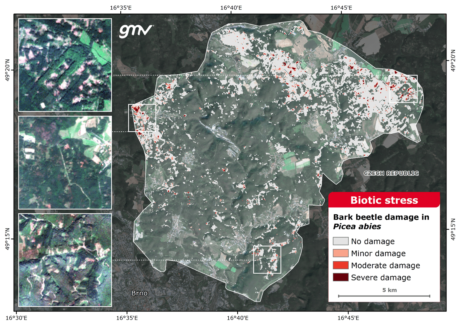
The product maps the forest areas affected by biotic stress and provides a qualitative classification of the biotic damage. In forestry, living organisms such as fungi, insects, bacteria, or weeds, among others, can damage the tree’s health, and consequently the forest health status. This product looks for detecting, delimiting and estimating woodland plague damage using satellite data and machine learning techniques.
- Sustainable forest management and conservation practices
- Forest monitoring
- Plague-damage detection system
- Lobbying and advocacy
- Forestry project monitoring and evaluation
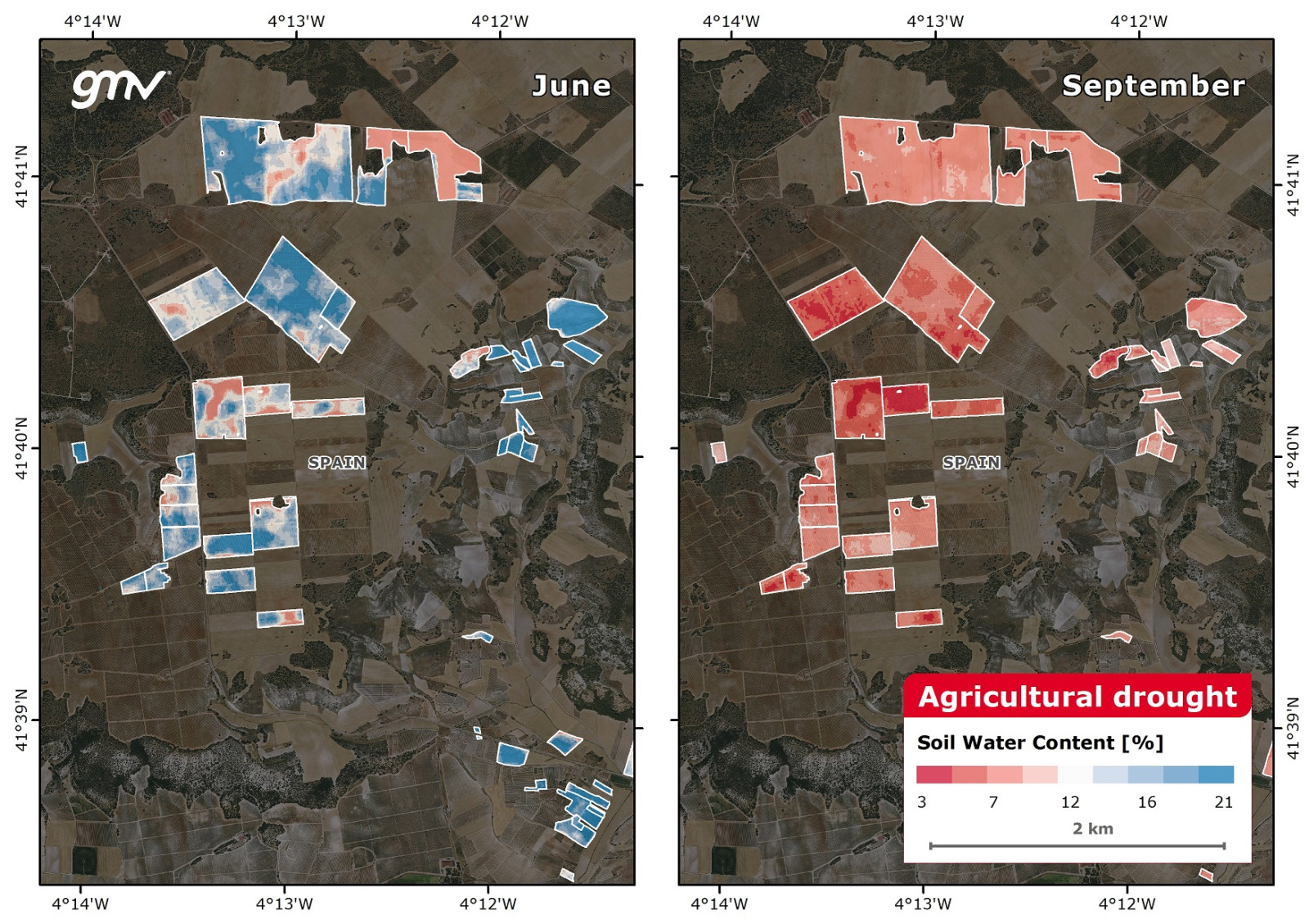
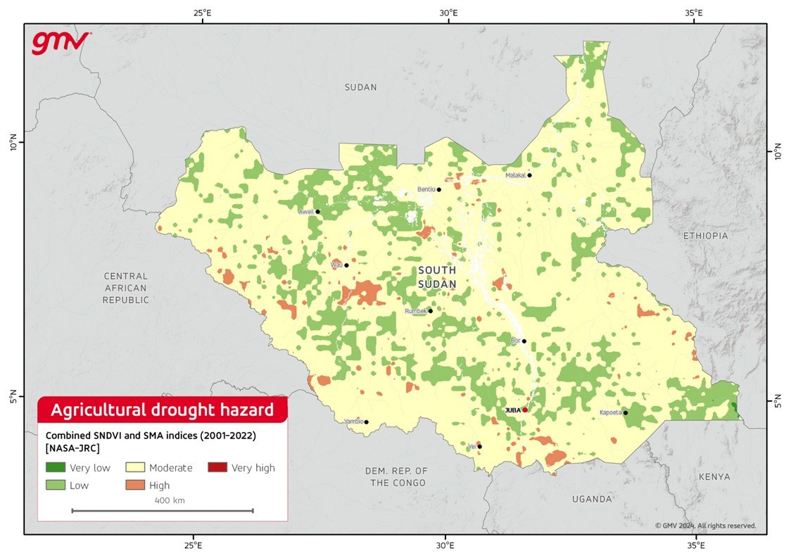
This product provides time-series information on vegetation biophysical variables and soil moisture from satellite optical imagery and meteorological reanalysis, and the analysis of drought indicator dynamics and anomalies. These elements are used to produce an agricultural combined drought indicator based on a cause-effect relationship.
- Identifying agricultural droughts
- Rainfed agriculture
- Food and nutrition security
- Terrestrial ecosystem
- Drought early warning decision support
- Mitigation of drought impacts
- Sustainable crop farming and livestock watering
- Finance
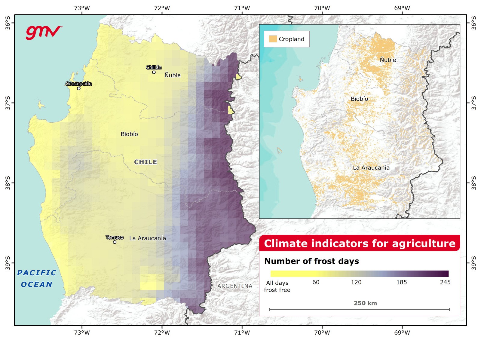
This product provides climate indicators aimed at classifying and quantifying the potential impacts of extreme climate events for agriculture. The indicators covered by this product are derived from satellite data, meteorological models, and climate models and are calculated following the common definitions internationally accepted by the scientific community. These indicators match globally accepted information, thus meeting agricultural needs for climate impact assessment.
- Climate change impact assessment
- Rainfed and irrigation agriculture
- Food and nutrition security

This product provides satellite information to support climate-resilient agriculture. This includes crop area monitoring and change assessment, crop type identification, estimated water deficit based on soil moisture, determining the available water in reservoirs, and monitoring ground water storage.
- Cropland change assessment
- Irrigated agriculture
- Intervention and investment in the agricultural sector
- Agriculture productivity assessment
- Rural infrastructure investment design, monitoring, and evaluation
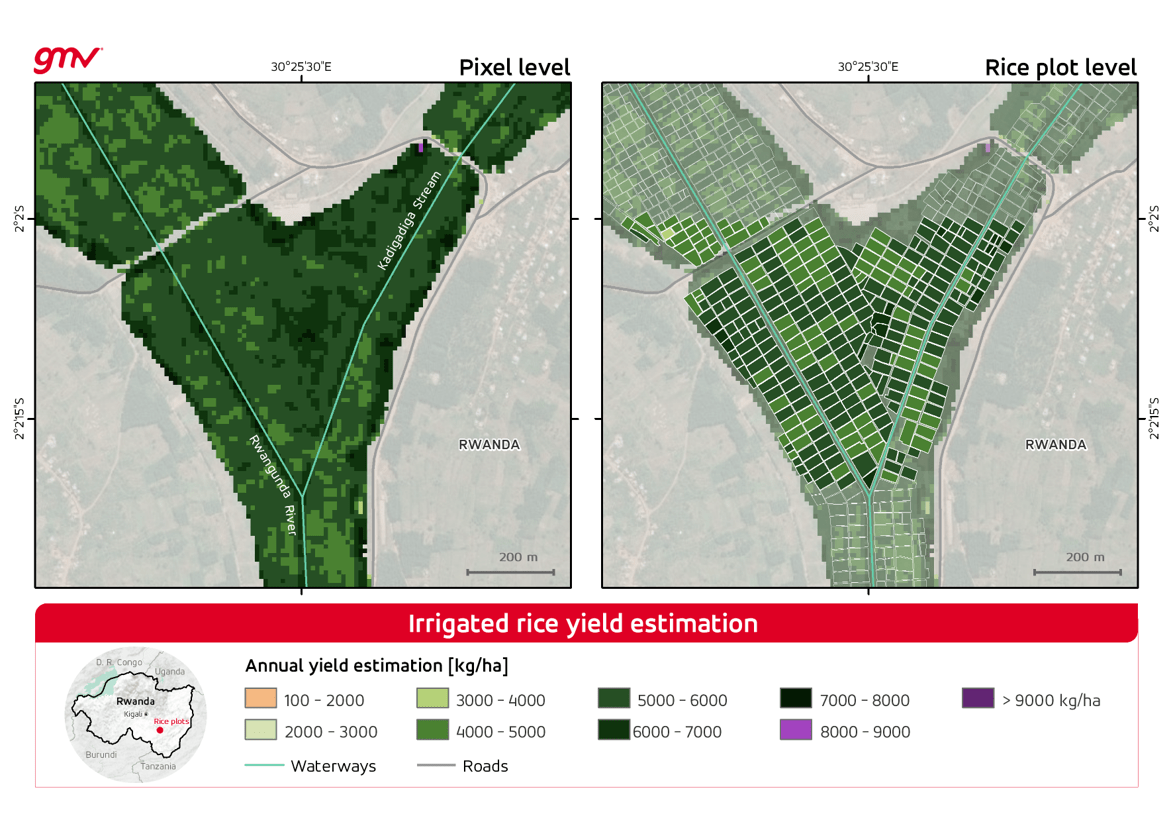
The product provides crop type mapping and biomass estimation, EO technology enables precise yield modelling. These models are calibrated using historical yield records to improve prediction accuracy, providing valuable insights for farmers, policymakers, and researchers. Reliable yield forecasts support strategic agricultural planning, resource optimization, and the development of effective food security policies.
- Agriculture productivity assessment
- Sustainable crop farming and livestock watering
- Rainfed and irrigated agriculture
- Food and nutrition security
- Interventions and financial investments in agriculture sector
- Support intervention policies at country and regional level
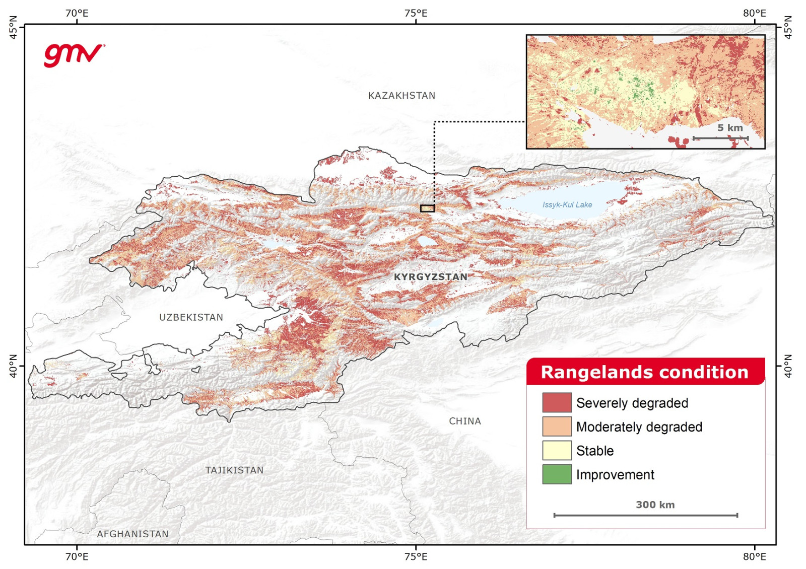
This product identifies rangelands and assesses long-term, seasonal changes for defined timespans. It computes biophysical vegetation indicators to assess rangeland productivity trends. Indices are weighted according to their capacity for condition assessment. The grazing practices of local pastoral communities are integrated for retrieval of pasture degradation.
- Project formulation and project impact assessment
- Climate policy formulation
- Food and nutrition security
- Identification of restoration opportunities
- Advocacy and lobbying on rangelands
- Data support for national government reporting on commitments
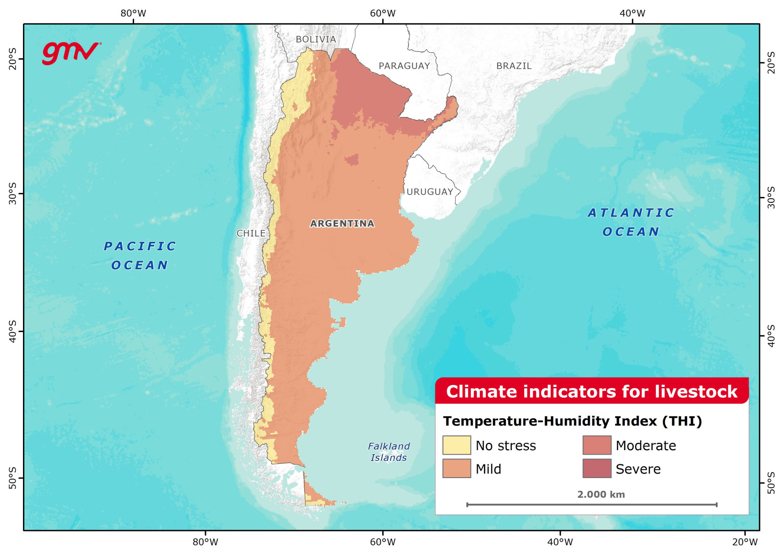
This product provides past, present, and future-projected information about environmental livestock stress. It covers temperature-humidity, wind-chill, and comprehensive climate indices. Heat/cold stress charts for particular species are necessary to properly assess impact. Indices are calculated using climate data from meteorological models and regional and global climate models.
- Livestock productivity
- Livestock development interventions
- Animal health and welfare
- Sustainable livestock farming
This product provides time-series information on the occurrence, frequency, and extent of water bodies, as well as anomalies in total water storage. The indicators include water occurrence, water occurrence change intensity, water surface persistence, water seasonality, total water surface area, annual water recurrence, and other descriptors of water dynamics.
- Identifying water dynamics
- Water supply
- Food and nutrition security
- Agriculture and livestock
- Hydrological modelling
- Energy and industry
- Aquatic and terrestrial ecosystems management

This product provides information on urban heat islands by measuring land surface temperatures from thermal satellite observations and ascertaining city air temperatures from meteorological data. It also includes mapping of urban green cover to analyze the impacts of green and built areas on urban heat islands.
- Urban planning
- Model thermal activity and ventilation in and around cities
- Providing information for climate-adaptive building design
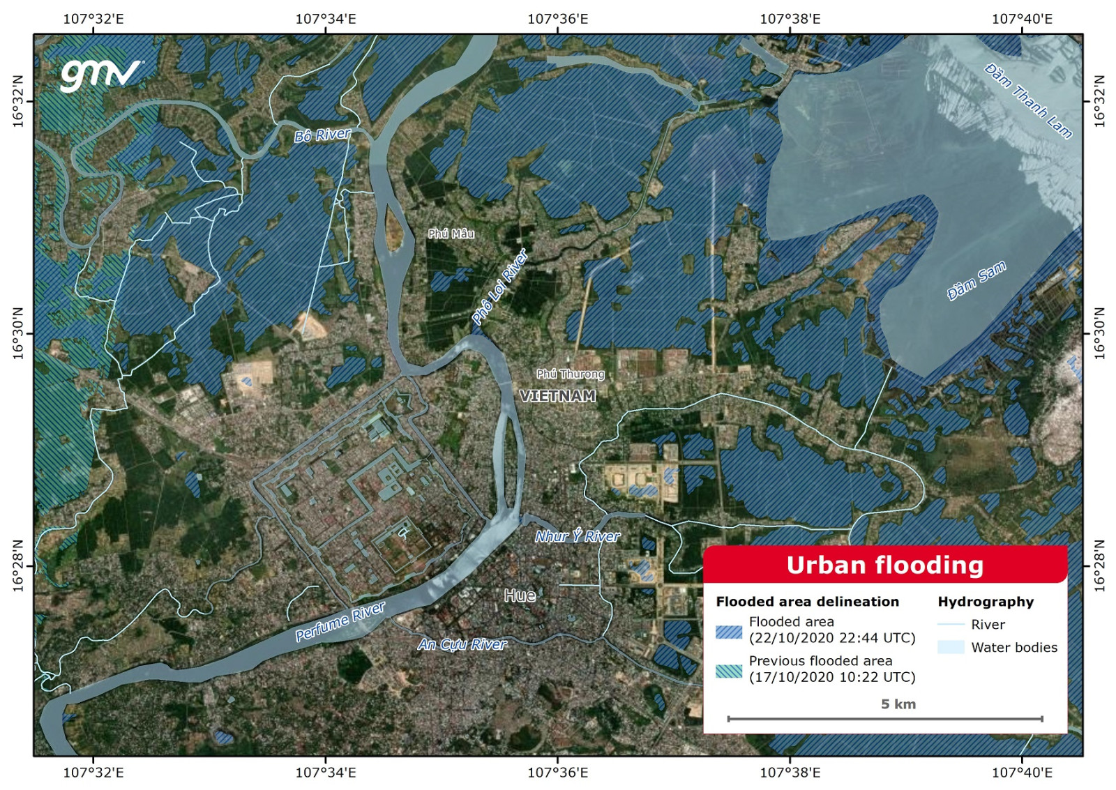
This product grades the damage and delineates the flood extent affecting an urban area. The drainage pattern of land is disrupted when a natural landscape is transformed by urban development. The accumulation of floodwaters resulting from the inflow of storm water can exceed the drainage capacity, leading to urban flooding.
- Urban planning
- Disaster risk management
- Damage evaluation
- Flood risk assessment
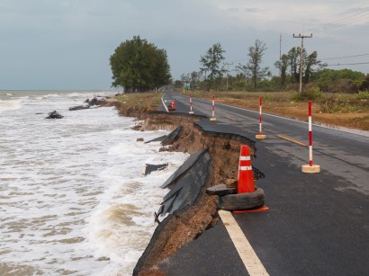
Floods
This product analyzes flood hazards by delineating and grading documented flood events and estimates the probability of floods. It maps historical flood events, analyzes socio-economic/ecosystem impacts caused by floods, estimates the current risk of river flooding for different return periods, and assesses river flood risk using future projections and RCP scenarios.
- Climate risk assessment
- Hydrological & hydraulic modelling
- Flood risk assessment
- Analyses of historical flood events
- Water resources management
- Support financial disclosure reports
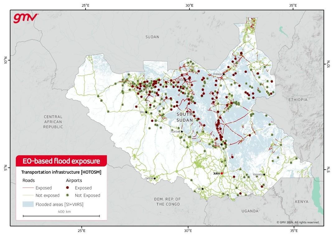
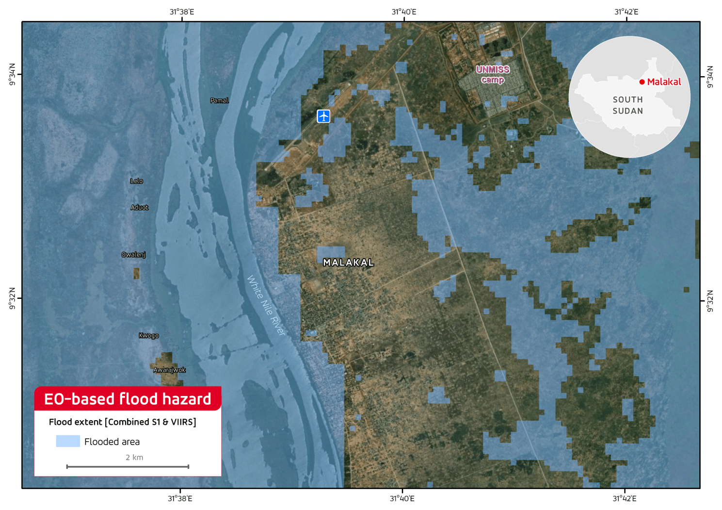
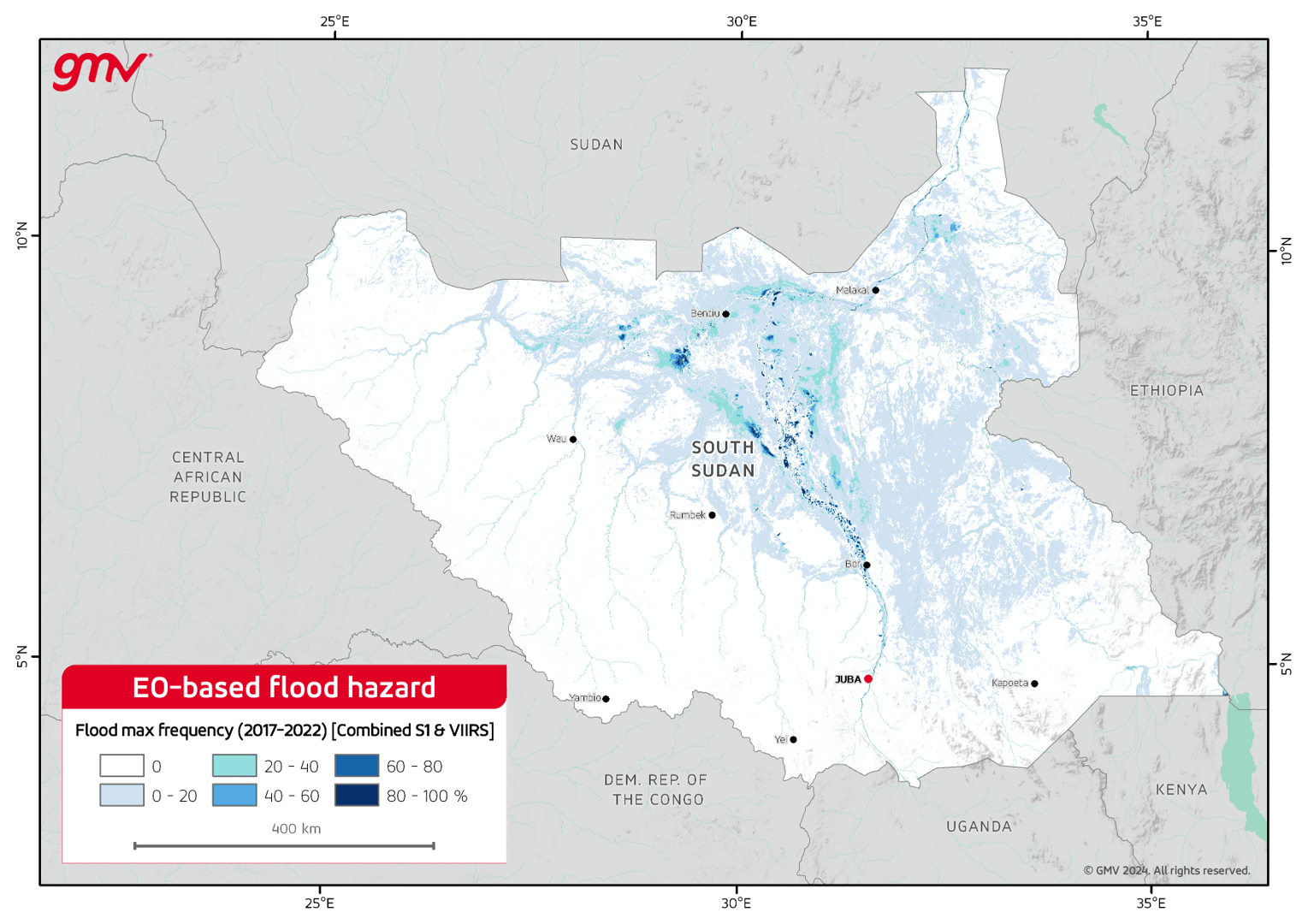
The product identifies flood-prone areas using Earth Observation from regional to national scale. By analyzing satellite imagery from diverse sensors, this product pinpoints flood-prone regions, their maximum extent, and the frequency of flooding.
- Hydrological & hydraulic modelling
- Flood risk assessment
- Flood risk management
- Analyses of historical flood events
- Estimations of water reservoir storage
- Water resources management
- Identifying water dynamics
- Disaster risk management
- Vulnerability assessment
- Support financial disclosure reports
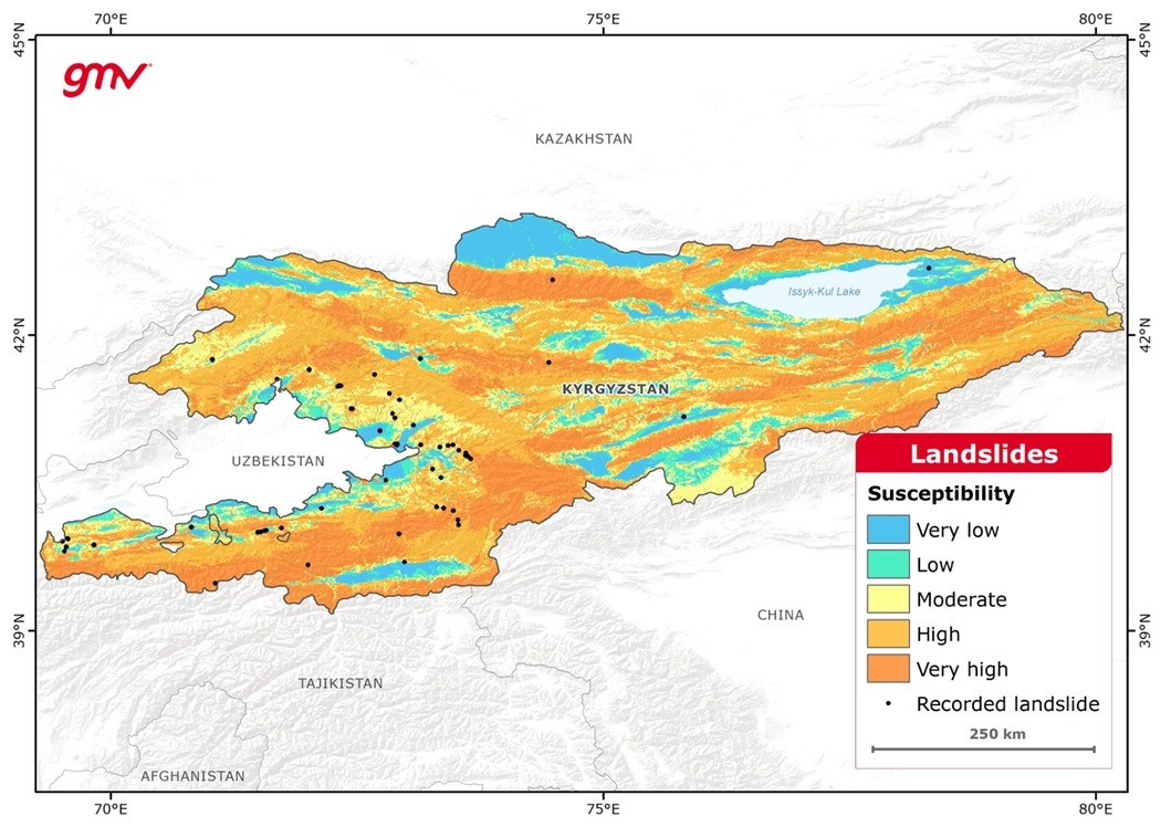
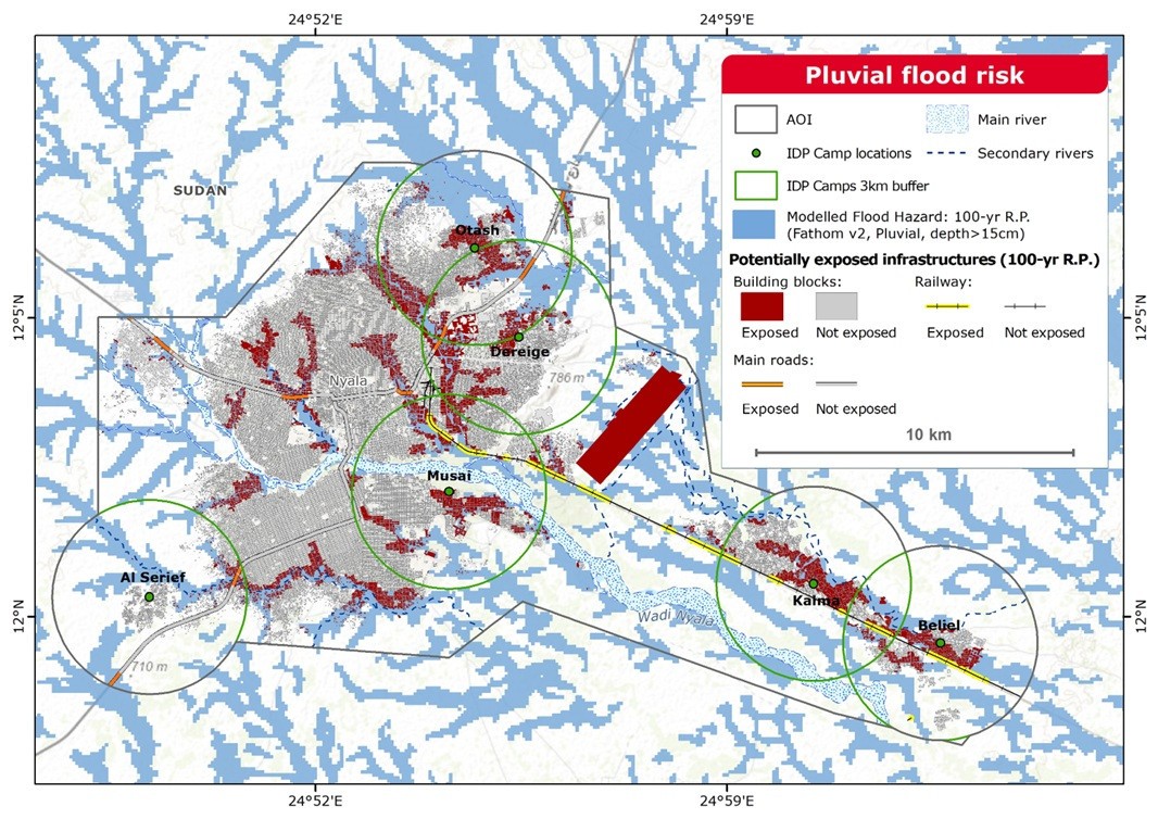
The product provides information for the assessment of landslide susceptibility in mountainous terrain. Susceptibility maps of landslides resulting from heavy rains are derived from rainfall-driven landslide models and analysis of event-based landslide records from repositories and delineations. Delineation and grading of historical events on susceptible areas is derived from EO radar and optical approaches.
- Climate risk assessment
- Landslide susceptibility assessment
- Landslide risk assessment
- Support financial disclosure reports
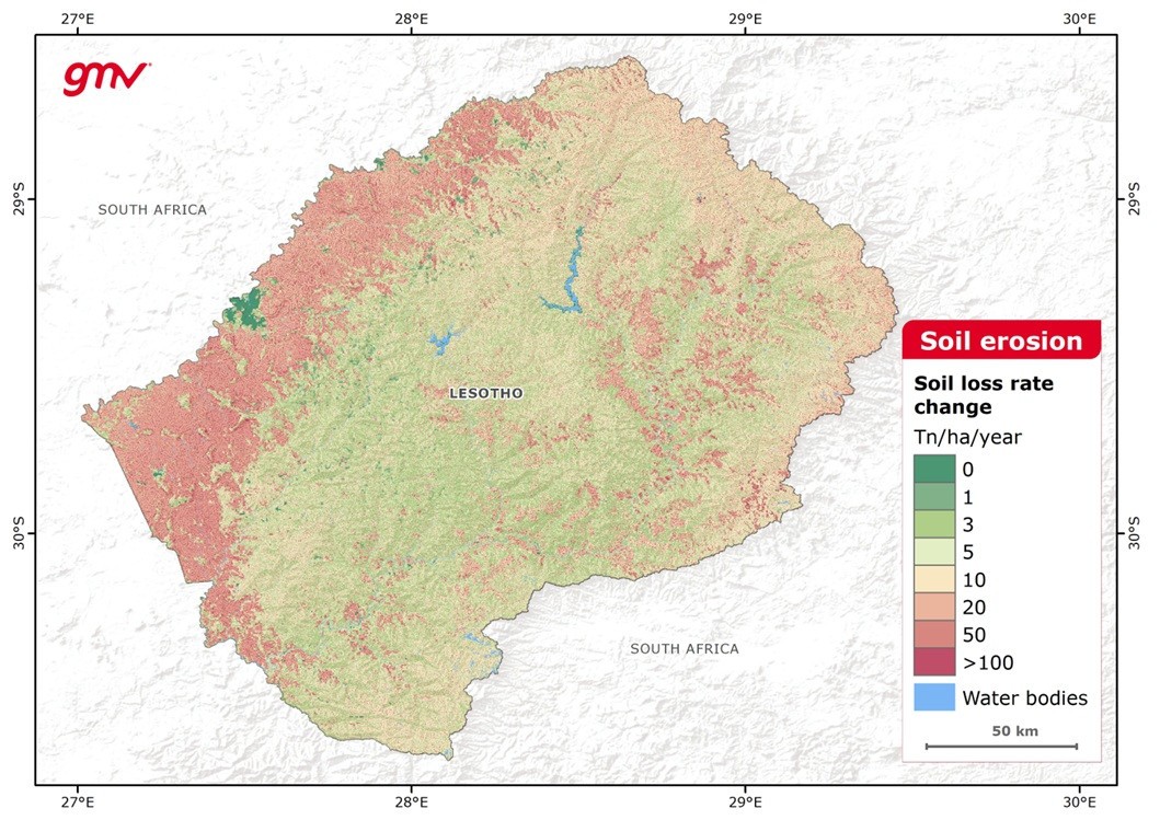
The product provides the water-related soil erosion trend over a defined period. Soil loss rates are derived in Tn/ha/year using the RUSLE2015 model and EO datasets. Factors affecting the soil loss that are calculated include: rainfall erosivity, soil erodibility, topography and cover-management.
- Climate risk assessment
- Soil erosion risk assessment
- Investment planning
- Identification of restoration opportunities
- Land use management
- Impact assessment on soil erosion mitigation measures
- Climate policy formulation
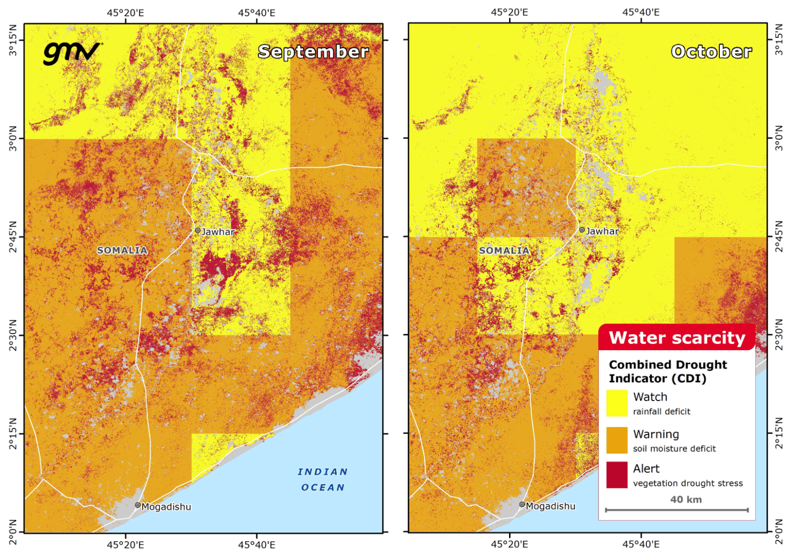
The product provides information on all components of a drought, including analysis of precipitation/evapotranspiration patterns, soil moisture anomalies, decrease of water bodies’ extents, total water storage anomalies, vegetation productivity, and dynamics of drought indicators. These elements are used to produce a combined drought indicator that is based on the cause-effect relationship.
- Drought risk assessment
- Drought management and action plans
- Drought early warning decision support
- Sustainable crop farming and livestock watering
- Drought modelling
- Mitigation of drought impacts
- Drought risk assessment
- Identifying meteorological droughts
- Identifying hydrological droughts
- Identifying agricultural droughts
- Detecting and monitoring long-term hydrological drought conditions
- Drought early warning decision support
- Drought modelling
- Mitigation of drought impacts
- Drought management and action plans
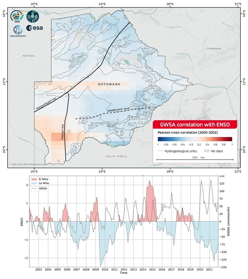
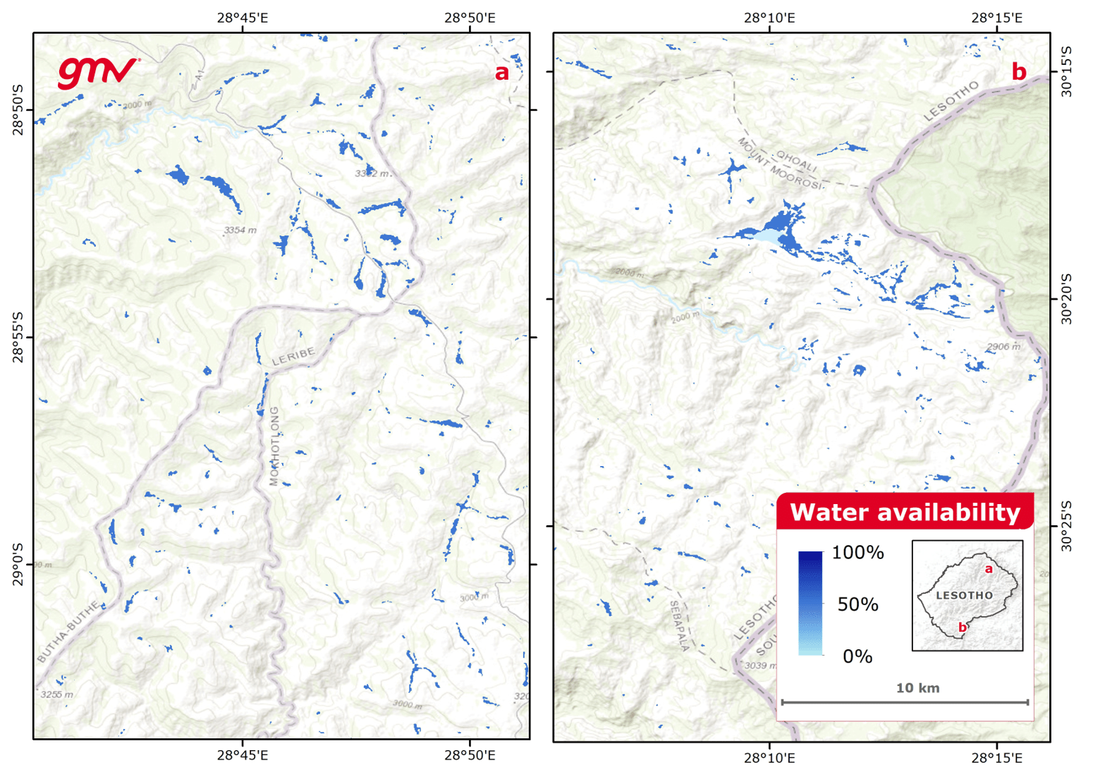
The product provides insights on how the main climate drivers control water resources availability. Based on remote sensing data and global datasets, it identifies patterns, trends, and correlations that affect water availability across regions and timeframes.
- Identifying water dynamics
- Water supply
- Water resources management
- Identifying meteorological droughts
- Detecting and monitoring long-term hydrological drought conditions
- Drought monitoring
- Climate risk assessment
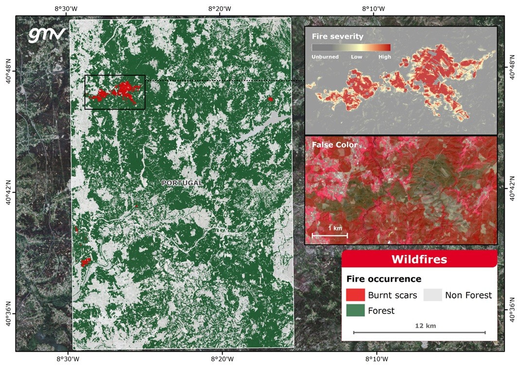
This product provides fire disturbance maps of medium spatial resolution using thermal anomalies, and higher spatial resolution employing combined optical and radar imagery for detection of burnt areas. This product supports post-disaster recovery plans by providing the area affected by the fire and estimating the fire severity and corresponding confidence level.
- Forest fire damage assessment and delineation
- Regional forest fire prevention action plans
- Environmental assessment
- Reforestation plan
- Forest and natural resources sustainable management
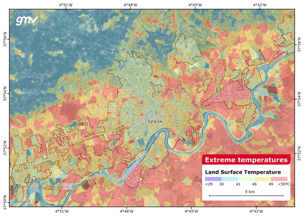
The product provides information on the heat and/or cold waves affecting a region. The product is obtained by measuring land surface temperatures from thermal observations of satellite, meteorological and ancillary data resources..
- Climate risk assessment
- Heat and cold waves assessment
- Urban planning
- Model thermal activity and ventilation in and around cities
- Inform climate-adaptive building design
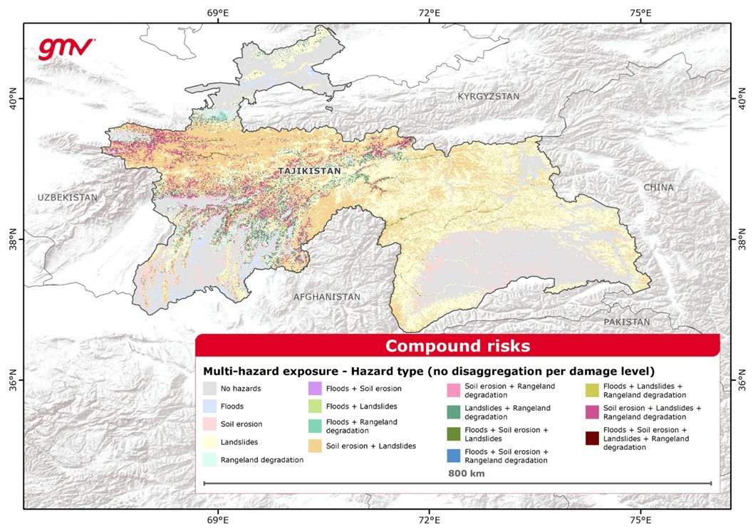
This product combines the EO-derived hazard damage level from floods, landslides, soil erosion, water scarcity, wildfire and extreme temperatures to produce multi-hazard maps that follow the definition by UNDRR. GIS techniques are used to create maps by classifying the hazard potential (low hazard to high hazard) and overlaying the information of the hazardous events. Climate-driven hazards are likely to intersect with other threats; compound risk maps can be developed to assess the collective impact.
- Climate risk assessment
- Risk evaluation in contexts of fragility, conflict, and violence
- Climate policy
- Compound risk monitoring and managing
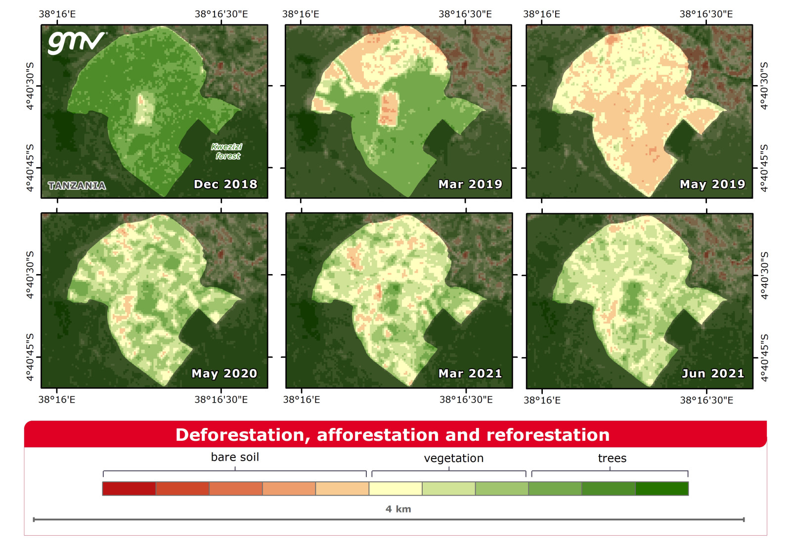
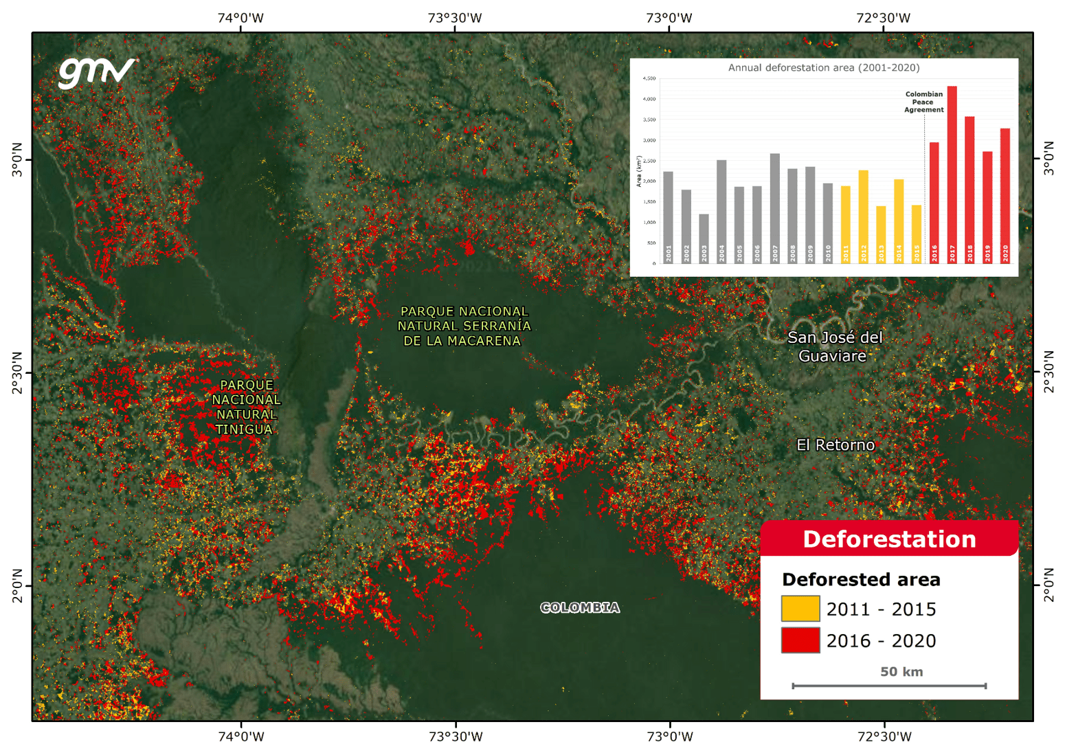
This product provides information on deforestation, as well as afforestation and reforestation activities in a region of interest. It includes time-series forest change detection and quantification, and the analysis of land cover dynamics.
- Sustainable forest management and conservation practices
- Nature-based solutions
- Tracking forest logging
- Monitoring deforestation in supply chains
- Forest monitoring
- Lobbying and advocacy
- Forestry project monitoring and evaluation
- Land use planning
- Tree planting opportunities
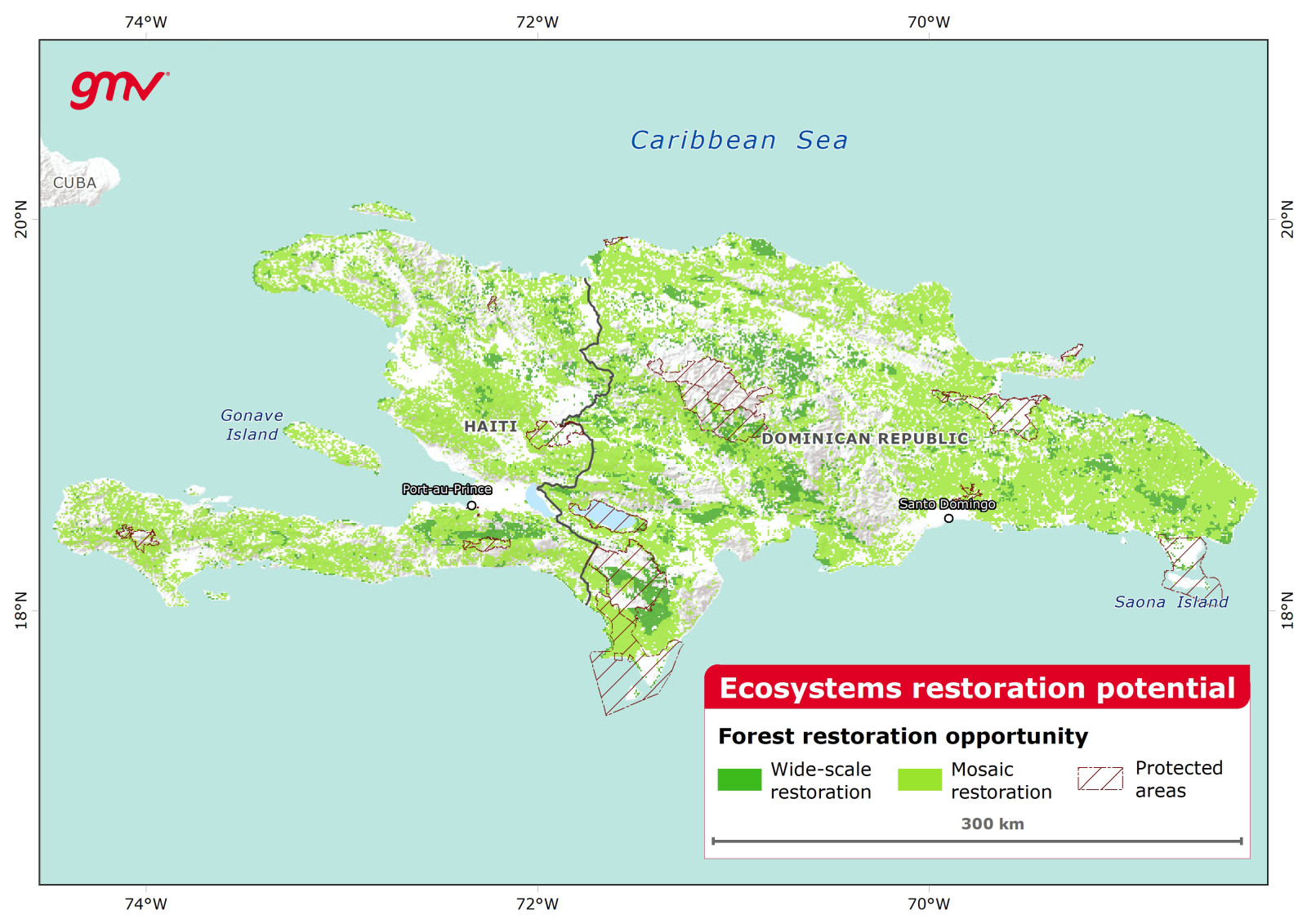
This product maps the opportunities for restoration on degraded lands, especially for forests. It includes analyses of the current coverage and condition of the ecosystem, the potential ecosystem coverage under current and future climate conditions, and the human pressure including population density, built areas, pasturelands, and croplands.
- Sustainable forest management and conservation practices
- Nature-based solutions
- Identifying tree planting opportunities
- Ecosystem restoration opportunities
- Conservation areas
- Ecosystem project monitoring and evaluation
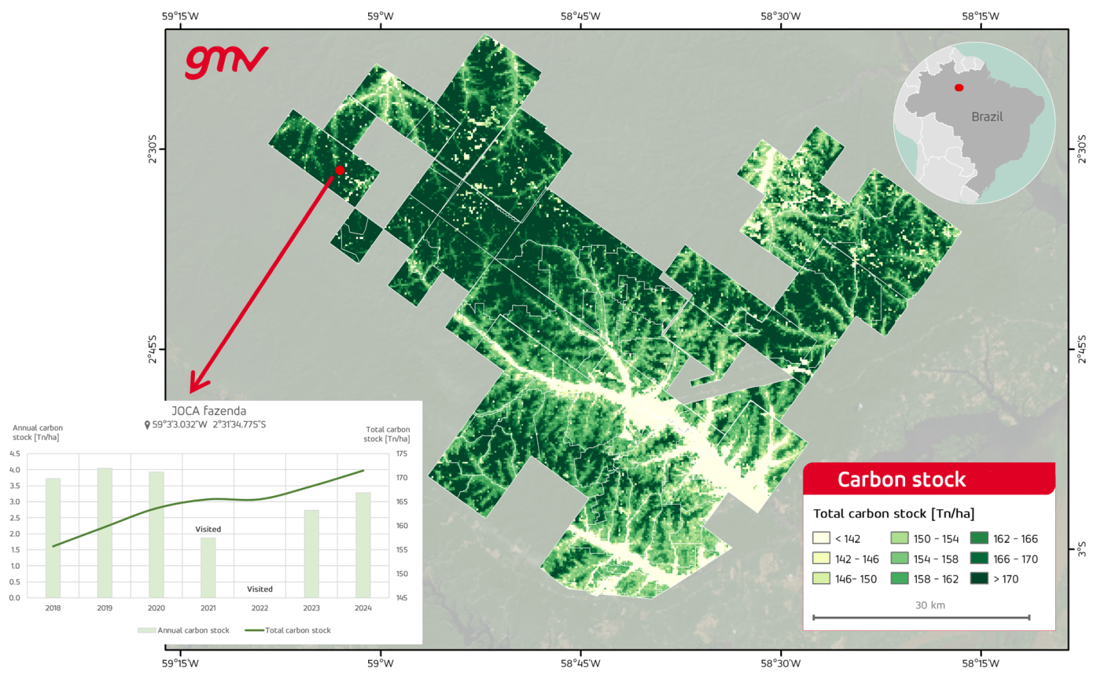
This product maps the carbon content of an area of interest from EO-based above-ground biomass measurements of forested areas and soil organic carbon estimates as a proxy for soil carbon stocks. Biomass estimates are retrieved from Lidar-based altimetry measurements combined with digital surface models.
- Creating national GHG inventories
- Carbon storage estimation
- Identifying restoration opportunities
- Climate financing
- Update of the UNFCCC’s nationally determined contributions (NDCs)
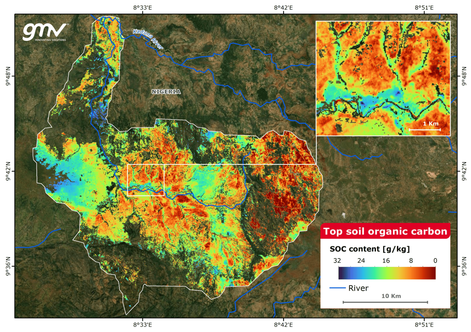
This product provides information to support all tiers of the IPCC’s Guidelines for National GHG Inventories. It calculates carbon stock changes to measure GHG emissions by monitoring changes in land use and estimating multi-source spatial variations on biomass density (forestry) and soil carbon (soils).
- Creating national GHG inventories
- Reporting on GHG emissions/removals
- LULUCF studies
- Carbon crediting (e.g. REDD+)
- Climate financing
- Update of UNFCCC’s nationally determined contributions (NDCs)
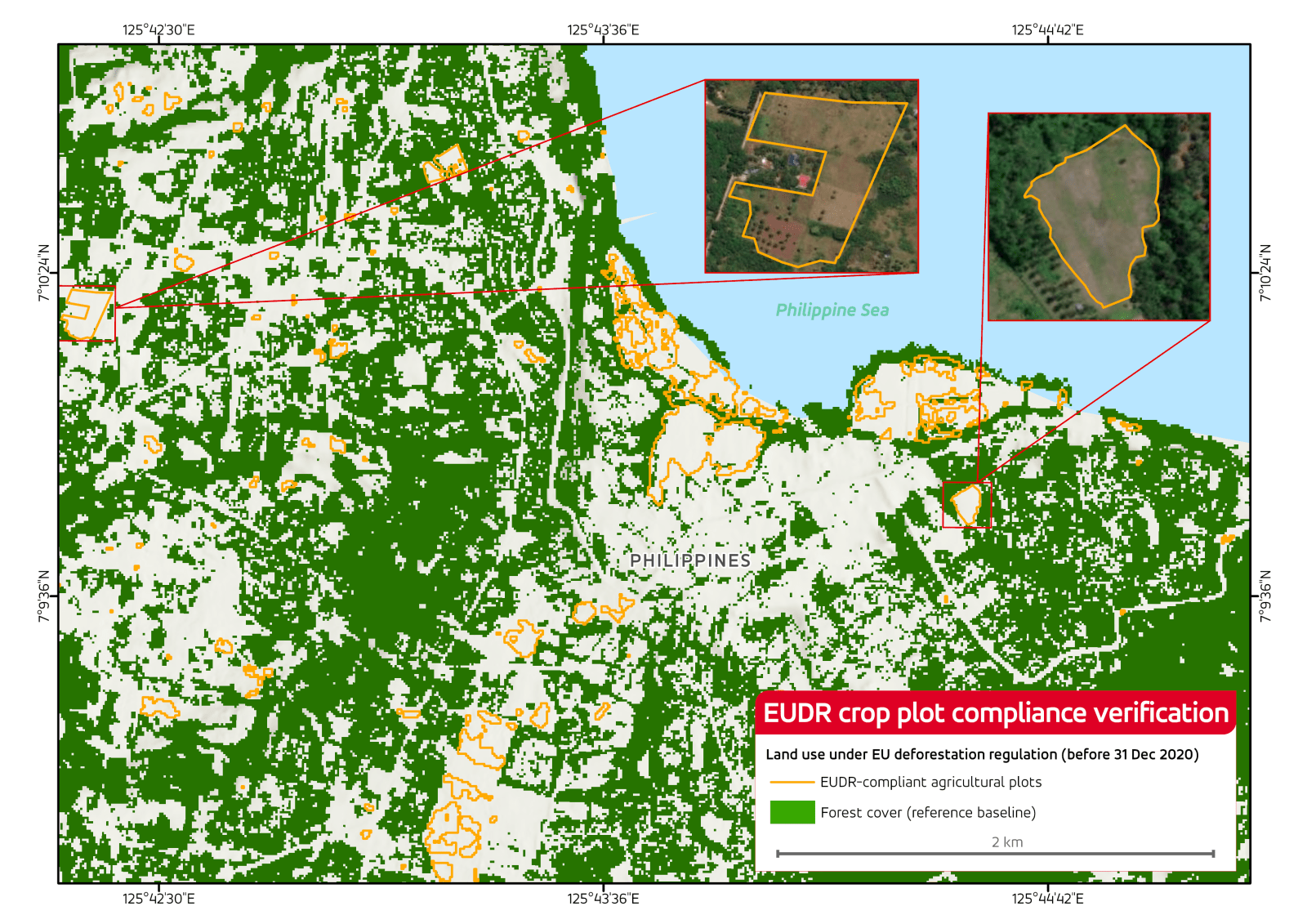
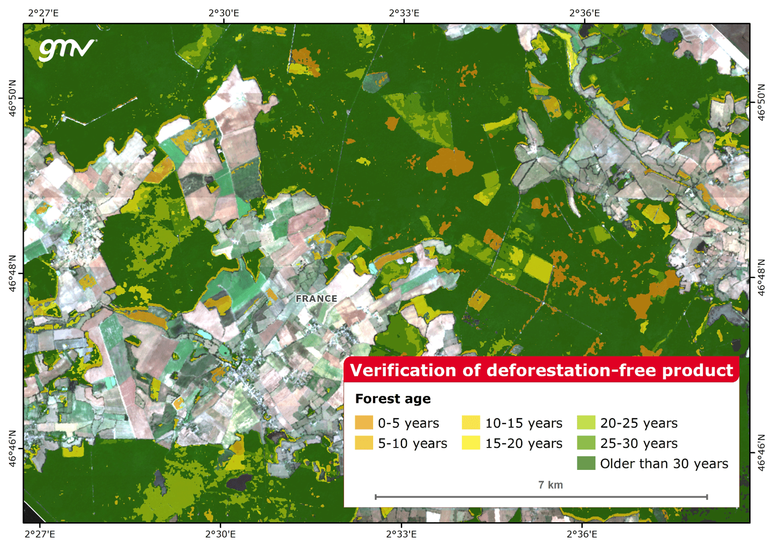
Provides EO-based information to verify commodity origin and compliance with sustainability and legality requirements. Supports due diligence reporting aligned with EU regulations, particularly the EU Deforestation Regulation, which requires proof that goods are not sourced from deforested land after 31 December 2020. Provides information for companies buying goods and placing them on the EU market.
- Tracking forest logging
- Monitor deforestation in supply chains
- Forest monitoring
- Sustainable forest management and conservation practices
- Support financial disclosure reports
- Climate policy formulation
- Ecosystem management
Provides EO-based insights and analytics to support sustainable forest management, conservation planning, and monitoring of forest harvesting and deforestation activities. These tools help distinguish legal logging from unauthorized operations, support enforcement and certification processes, assess compliance with conservation goals, and evaluate the impact of forest policies over time.
- Sustainable forest management and conservation practices
- Forest monitoring
- Tracking forest logging
- Monitor deforestation in supply chains
- Forest project monitoring and evaluation
- Support enforcement and certification processes
- Assess compliance with conservation goals
- Evaluate the impact of forest policies over time